
Search Results
9 Results found


Karte des Mahakam-Flusses in Borneo: Nach den aufnahme der Niederländischen Expedition zur Durchquerung Borneo's, 1896-1897
1898
Indonesia, Malaysia
Map of the Mahakam River in Borneo, based on an expedition by the Dutch explorer Dr. Anton Nieuwenhuis in the late 19th century. An inset map shows the upper reaches of the river at twice the scale of the main map.

Geologische übersichts- und vulkan-karte von Java und Madura
1898
Indonesia
Geological map of Java and Madura, showing rock types and the locations of volcanoes. There are two cross sections (elevations) showing the heights of terrain: one of Java; and one from Cambodia to the Indian Ocean, including Borneo and Java.

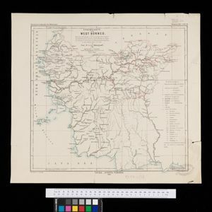
Stromkarte von West Borneo... mit Angabe der Stationen und Routen der Niederländischen Expedition in den Jahren 1893 und 1894
1895
Indonesia
The route of a late 19th century expedition by Dutch geologists, botanists, ethnographers and zoologists is marked on this map of southwest Borneo. Mountain peaks which were surveyed by the geologists are highlighted with a red circle.


Schutzgebiet der Neu-Guinea-Kompanie
c.1892-1893
Indonesia, Papua New Guinea
Very detailed six-sheet map of eastern New Guinea, with numerous inset maps of bays and islands, and other inset maps covering ethnography, explorers of the region, marine routes across the Pacific Ocean, cannibalism, missionaries activity etc.

Reduzirte Karte vom Sunda- oder Borneo-Meere
1835
Malaysia, Indonesia
A navigation map of the Java Sea and Sunda Islands, with bathymetry (sea depth), maritime routes, shoals and reefs, and elevations (side views of terrestrial landmarks). Inset maps feature the bay at Batavia and the straits between the Sunda Islands.

Reduzirte Karte von den Philippinen und den Sulu Inseln
1832
Malaysia, Indonesia, Philippines
Maritime map of the Philippines, with inset maps of bays showing bathymetry (sea depth), shoals, reefs and anchor points. There is also an inset map of Taal Volcano, and elevations (side views of terrestrial landmarks like mountains and islands).


