
Search Results
162 Results found


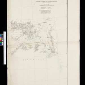
Index to relative positions of gold mining & prospecting grants: District Katha
1893
Myanmar
Map of the Katha district, Burma (Myanmar), with locations of gold mines and land allocated for prospecting. High points are marked and linked with lines to create a triangulation network. The Mu Valley State Railway and Mu River are shown.


No. 4 preliminary chart of the principal triangulation of the Mandalay meridional series
1893
Myanmar
A triangulation map of part of Upper Burma (Myanmar), showing nine locations (‘hill stations’) joined with straight lines to create a triangulation network. Each hill station’s latitude and longitude, height above sea level, and description is given.


Portion of coal fields tract: Upper Chindwin district
1892
Myanmar
A map surveying coal fields close to the Chindwin River in Upper Burma (Myanmar). Mountains are shown by using hachures: short lines/dashes that give a sense of the shape and steepness of terrain. Survey stations are marked with their height.

Map to accompany preliminary report on the Chin-Lushai Country
1892
Myanmar
Topographical map of the mountainous border region between India and northwest Burma (Myanmar), showing rivers, lakes, villages, towns, roads and railways. High points are marked with their heights so they can be used for triangulation.
- Filter from 1683 to 1900
- [remove]Myanmar162
- Thailand117
- Malaysia95
- Indonesia92
- Laos86
- Vietnam86
- Cambodia83
- Singapore83
- Brunei69
- Philippines68
- Southeast Asia65
- East Timor62
- more Simple Location »


