
Search Results


Plan d'Amboine, tel qu'il étoit en 1718 = Platte-grond van Amboina, zoo als het was in den jaare 1718
c.1746-1770
Indonesia
This colourful mid-18th century plan of the city of Amboine (Ambon, capital of Ambon Island, in the Maluku Islands, Indonesia) has a detailed legend identifying locations within the city and the surrounding mountains. The text is in French and Dutch.

Plan de la ville et forteresse de Malaca: pour servir à l'histoire generale des voyages
1750
Malaysia
This mid-18th century plan of the city of Malaca (Malacca/Melaka) focuses on the military fort (‘A Famosa [The Famous]’), but also includes two churches, a mosque and a Chinese temple. Two markets are also marked, as is the entrance to the port.

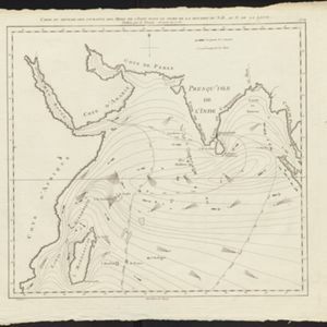
Carte du sisteme des courants des Mers de l'Inde dans le tems de la Mousson du N.E, au N. de la ligne
1776
Indonesia, Myanmar, Thailand
Map of the Indian Ocean showing the currents (represented by arrows) and winds (represented with letters A to G) during the monsoon seasons. Three routes from the Isle de France (Mauritius) around the Indian Ocean are shown.
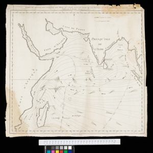
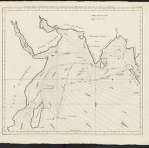
Carte du sisteme des courants des Mers de l'Inde dans le tems de la Mousson du N.E, au N. de la ligne
1776
Myanmar, Indonesia, Thailand
Map of the Indian Ocean showing the currents (represented by arrows) and winds (represented with letters A to G) during the monsoon seasons. Three routes from the Isle de France (Mauritius) around the Indian Ocean are shown.
Carte des courants pour le tems de la Mousson du S.O., au N. de la ligne
c.1780
Malaysia, Indonesia, Myanmar, Thailand
Map of the Indian Ocean showing the currents (represented by arrows) and winds (represented with letters A to F) during the monsoon seasons. Three routes—one old and two new—from the Isle de France (Mauritius) east to the Strait of Malacca are shown.


Carte des courants généraux dans l'Océan Indien
c.1849-1863
Brunei, Cambodia, East Timor, Indonesia, Laos, Malaysia, Myanmar, Philippines, Singapore, Southeast Asia, Thailand, Vietnam
Map of the Indian Ocean showing the currents (represented by arrows), including during the North East and North West monsoons. Numbers on the arrows indicate the current’s speed.

Mer des Indes: cartes de la direction et de l'intensité probables des vents
1880
Brunei, Cambodia, Indonesia, Malaysia, Myanmar, Philippines, Thailand, Vietnam, Singapore
A series of four maps of the Indian Ocean—one for each quarter of the calendar year—showing the direction and intensity of the winds, including around the seas of Southeast Asia. There are extensive explanatory notes.


