
Search Results


Route chart to India and the East
1895
Brunei, Cambodia, East Timor, Indonesia, Laos, Malaysia, Myanmar, Philippines, Singapore, Southeast Asia, Thailand, Vietnam
Map of Asia featuring steamship routes—including around Southeast Asia—connecting ports such as Penang, Singapore, Batavia (Jakarta), Saigon, Bangkok, Rangun (Yangon), Manila, Macassar (Makassar) etc. There is also an inset map of Singapore.

Kaart van het gebied bezet in Groot-Atjeh
1895
Indonesia
A large-scale map of Aceh, north Sumatra, spread over four sheets with details such as routes (rivers, roads, railways), crops (rice, banana, pepper, sugarcane, bamboo), land features (mountains, forests, wetlands) and settlements (cities, villages).

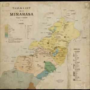
Sumatra: Residentie Benkoelen (Bengkoelen)
c.1894-1895
Indonesia
Map of the residency of Benkoelen (Bengkulu, southwest coast of Sumatra), over 10 sheets, with an inset map of the city of Bengkoelen (Bengkulu). Types of crops—coconut, rice, alang-alang, nipah palm, coffee—are marked. Sheet number 8 is missing.


Kaart van Ampenan, Mataram en Tjakranagara met aangrenzend terrein
1895
Indonesia
A map of Mataram in the late 19th century showing it as a kampong (village) surrounded by paddy fields (rectangular parcels of land for growing rice). The map’s whole area is now just part of what is the largest city on the island on Lombok.


Kaart van het Westelijk gedeelte bezet in Groot-Atjèh
1895
Indonesia
This map of Groot-Atjèh (Aceh, northern Sumatra) focuses on the western part occupied during the Aceh War. It shows mountains, wetlands, forests, villages, routes and crops (rice, coconut, banana, sugar, sugarcane, bamboo, alang-alang, betel).

- Filter from 1726 to 1900
- [remove]Kampong/Village253
- Residential Area91
- Military Fort70
- Cemetery/Columbarium68
- Post Office67
- Church46
- Temple46
- Military Barracks41
- Hospital39
- Mosque33
- Public Space25
- Jail/Prison24
- Police Station21
- Palace17
- more Settlement Features »


