Search

Search Results

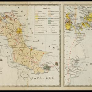
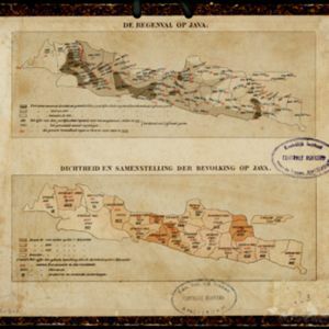
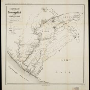
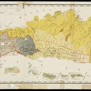
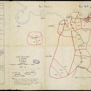
Kaart van Zuid Celebes met uitzondering van het rijk Gowa

event1890

location_onIndonesia

Detailed topographical map of South Celebes (Sulawesi) spread over four sheets, featuring crops (coffee, alang-alang, rice), fishing ponds, salt panning. With two additional maps of the island of Saleijer (Selayar) and Pitoempanoewae (Pitumpanua).

Schets-taalkaart van de residentie Bangka / Schets-taalkaart van den Riouw- en Lingga-archipel

event1889

location_onIndonesia

Two separate maps showing the languages and dialects spoken on the islands of Bangka, and the Riouw (Riau) and Lingga archipelagos, in the late 19th century. On Bangka alone, there are 12 languages or dialects listed.

De regenval op Java / Dichtheid en samenstelling der bevolking op Java / Cultuurgewassen op Java / Veestapel op Java

event1889

location_onIndonesia

Four maps recording the rainfall, population and ethnicity, crops, and livestock of Java in the late 19th century.

Kaart van de residentie Oostkust van Sumatra

event1889

location_onIndonesia

Detailed topographical map of the east coast of Sumatra, spread over 36 sheets plus a cover sheet of the whole area. Mountains and forests dominate, with villages, routes and administrative borders shown. With five inset maps of individual towns.

Schetskaart der afdeeling Westkust van Atjeh

event1888

location_onIndonesia

From a Dutch geographical society journal, this map of the west coast of Atjeh (Aceh), Sumatra, shows shoals, reefs, bathymetry (sea depth) and anchor points. On land, there are mountains (with heights), rivers, pepper plantations and rice fields.

Schetskaart van het stroomgebied der beneden-Ketaun

event1888

location_onIndonesia

This map of the lower basin of the Ketaun River features a number of rivers flowing to the sea at the southwest coast of Sumatra. Between the rivers are large areas of forest (‘Zwaar woud’), mountains, villages, roads, hot springs and fields.

Topographische kaart der residentie Besoeki

event1888

location_onIndonesia

The residency of Besoeki (Besuki), East Java, featuring crops (rice, alang-alang, bamboo, coconut); fishing ponds; factories, warehouses, businesses; routes, administrative borders; churches, cemeteries, forts, lighthouses; mountains, rivers, lakes.

Topographische kaart der residentie Pasoeroean

event1887

location_onIndonesia

The residency of Pasoeroean (Pasuruan), East Java, featuring crops (coffee, cinchona (kina), rice, alang-alang, bamboo) and fishing ponds. Two inset maps: a triangulation map, and a map of distances between settlements by various types of transport.

Topographische kaart der residentie Madoera

eventc.1885-1887

location_onIndonesia

Three-sheet topographic map of the residency of Madoera (Madura, East Java), with an inset map of distances between locations. Administrative districts, crops—bamboo, sugarcane, alang-alang, rice, coconut, betel—salt pans and fishing ponds are shown.

Kaart van het Zuidwestelijk gedeelte van het landschap Mampawah, residentie Wester-afdeeling van Borneo

event1887

location_onIndonesia

Map of the crops—coconut, alang-alang, rice, nipa palm, bamboo—grown along the Mempawah River (west coast of Borneo). There are also large areas of swampy forest, Malay mosques, shrines and graveyards, and Chinese villages, temples and graveyards.

Schets-Taalkaart van Sumatra

event1887

location_onIndonesia

This map is colour-coded to show the different languages and dialects spoken in Sumatra in the late 19th century.

Schetskaart der onderafdeeling Toba: aantoonende de verdeeling in hoendoelans of negorijen

event1886

location_onIndonesia

Hand-drawn map of the district of Toba at the southern shore of Lake Toba, Sumatra, further divided into administrative areas (details of which are listed). Roads and paths are marked, and there are two missionary buildings indicated with crosses.

close

  • Filter from 1817 to 1899

Current results range from 1817 to 1899