Search

Search Results

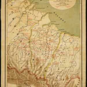
Kaart der afdeelingen Boelèlèng en Djambrana, eiland Bali, vervaardigd in 1885

event1886

location_onIndonesia

Contour lines show the terrain of these two districts at the western end of the island of Bali. Roads connecting the ‘desa’s [villages]’, Hindu temples and rivers are marked. Anchor points around the coast are marked for ships or for local vessels.

Kaart van Atjeh en Onderhoorigheden

event1886

location_onIndonesia

This map of the Atjeh and its surrounding area (modern province of Aceh, Indonesia) is divided into administrative areas. There is an inset map of the capital city Kota Radja (Banda Aceh), and mountains (with their height) and rivers are marked.

Kaart van Zuid Celebes met uitzondering van het Rijk Gowa

event1886

location_onIndonesia

Map of the South Peninsula of Celebes (Sulawesi), spread over four sheets. It features crops (alang-alang, coffee, rice, sugarcane), fishing ponds, salt panning, routes, mountains, forests and settlements. The Gowa Regency is left blank.

Topographische kaart der residentie Probolinggo

eventc.1884-1885

location_onIndonesia

Four-sheet topographic map of the residency of Probolinggo (East Java), with an inset map of distances between locations by rail and road, and a signal map. Crops, fishing ponds, sugar factories, and coffee and salt warehouses are shown.

Het stroomgebied van Bila en Pane: Opgenomen en in kaart gebracht... gedurende de jaren 1876, 1877, 1878, 1882, 1883, 1884

event1885

location_onIndonesia

A map of the watershed of the Bila and Pane rivers in northern Sumatra. In addition to many rivers/tributaries, mountains, roads, paths and administrative borders are marked. Side views of mountains (elevations) are shown to use a landmarks.

Kaart van Java en Madura

event1885

location_onIndonesia

This map of Java and Madura is divided into administrative areas: residencies (blue lines), departments (green) and districts (yellow). The locations of government coffee and salt warehouses, as well as railways and tramways (red lines) are marked.

Kaart van Deli: Afdeeling der residentie Oostkusst van Sumatra

event1884

location_onIndonesia

Map of Deli on the east coast of Sumatra, dominated by the numerous rivers that flow from the mountains in the southwest to the Strait of Malacca. The railway lines around the city of Medan are shown in red, and flags indicate a military garrison.

Topographische kaart der residentie Soerabaja

event1884

location_onIndonesia

The residency of Soerabaja, East Java, featuring crops (coffee, coconut, sugarcane, rice, alang-alang, bamboo) and fishing ponds. Three inset maps: a triangulation map; a map of distances between settlements by types of transport; Bawean Island.

Kaart van een gedeelte der Oostkust van Sumatra (Langkat, Deli en Serdang) waar tabaks-plantingen zijn

event1884

location_onIndonesia

Map of tobacco plantations in three regencies on the east coast of Sumatra. Each plantation is marked in red with the name of the brand under which its tobacco is imported into the Netherlands. Roads, railways and rivers are also shown.

Kaart aangevende 1°. de verdeeling van Java en Madura in gewesten en wat de gouvernements-residentiën betreft, ook in afdeelingen en districten

event1884

location_onIndonesia

This late 19th century map shows Java and Madura divided into regencies and departments, and further divided into districts. Government land used for growing coffee, businesses, agriculture, railways, postal routes and major roads are also shown.

Overzichtskaart van Groot-Atjeh

event1884

location_onIndonesia

Map of Groot-Atjeh (Aceh, Sumatra) divided into administrative districts. Mountains, forests, villages, railways, roads and rivers are marked. There are inset maps of Poeloe Bras (Breueh Island), and showing distances between larger settlements.

Topographische kaart der residentie Batavia

eventc.1882-1883

location_onIndonesia

The residency of Batavia, West Java, featuring plantations (coffee, tea, coconut, cinnamon, nutmeg, sugar); crops (rice, alang-alang, bamboo); fishing ponds; factories, warehouses, shops; routes, administrative borders; mountains, rivers, lakes.

close

  • Filter from 1817 to 1899

Current results range from 1817 to 1899