![](https://historicalmaps.yale-nus.edu.sg/rails/active_storage/representations/eyJfcmFpbHMiOnsibWVzc2FnZSI6IkJBaHBBcXNFIiwiZXhwIjpudWxsLCJwdXIiOiJibG9iX2lkIn19--77aa6576e00002d17f9671e5e36fe5ffc06b0fd7/eyJfcmFpbHMiOnsibWVzc2FnZSI6IkJBaDdCam9MY21WemFYcGxTU0lNTkRBd2VETXdNQVk2QmtWVSIsImV4cCI6bnVsbCwicHVyIjoidmFyaWF0aW9uIn19--bc467f5637e8b6d3bfb826116f92b6bfedfbf03a/leiden-2012267.jpeg)
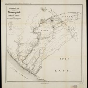
Schetskaart van het stroomgebied der beneden-Ketaun
1888
Indonesia
This map of the lower basin of the Ketaun River features a number of rivers flowing to the sea at the southwest coast of Sumatra. Between the rivers are large areas of forest (‘Zwaar woud’), mountains, villages, roads, hot springs and fields.