
Search Results


Topographische kaart der residentie Djokjakarta
1892
Indonesia
The residency of Djokjakarta (Yogyakarta), southern Java, featuring crops (coffee, sugar, rice, alang-alang, tobacco, indigo plants, nipa palm, bamboo); warehouses, cemeteries, post offices; routes, administrative borders; mountains, rivers.

Topographische Kaart der residentie Pekalongan
1892
Indonesia
Topographic map of the residency of Pekalongan (Central Java), divided into regencies (pink borders) and districts (yellow borders). Mountains, forests, settlements, routes, crops—alang-alang, coffee, sugar, rice—factories and warehouses are shown.


British Burma, Pegu division: With additions to railways up to 1891
1891
Myanmar
Topographical map of the Pegu Division of British Burma (Myanmar), spread over four sheets. In addition to mountains, forests, rivers and wetlands, rice fields, routes (road, railway, path, telegraph), villages and pagodas are marked.
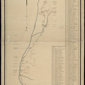
[Omgeving van het Toba meer, afdeelingen Bataklanden, onderafdeelingen Samosir, Toba en Hoogvlakte van Toba]
1890
Indonesia
Hand-drawn map of the southern part of Lake Toba in Sumatra, with roads, rivers and paths marked. Mountains, forest and rice fields are also shown, as are missionary buildings for indigenous and European people.

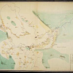
Kaart van Zuid Celebes met uitzondering van het rijk Gowa
1890
Indonesia
Detailed topographical map of South Celebes (Sulawesi) spread over four sheets, featuring crops (coffee, alang-alang, rice), fishing ponds, salt panning. With two additional maps of the island of Saleijer (Selayar) and Pitoempanoewae (Pitumpanua).

Kaart van de residentie Oostkust van Sumatra
1889
Indonesia
Detailed topographical map of the east coast of Sumatra, spread over 34 sheets. The area’s farms are listed and shown on the map, with types of crop grown. With five inset maps of individual towns. Two sheets and the cover sheet are missing.

Kaart van de residentie Oostkust van Sumatra
1889
Indonesia
Detailed topographical map of the east coast of Sumatra, spread over 36 sheets plus a cover sheet of the whole area. Mountains and forests dominate, with villages, routes and administrative borders shown. With five inset maps of individual towns.

- Port22
- Railway Station17
- Pier15
- [remove]Road118
- River110
- Path85
- Postal Route43
- Railway/Tramway37
- Bridge34
- Canal24
- Telegraph/Telephone13
- [remove]Jungle/Wooded Area118
- Mountain/Volcano99
- Wetlands86
- Wild Animals4
- Mangrove3


