
Search Results

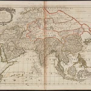
L'Asie
1669
Brunei, Cambodia, East Timor, Indonesia, Laos, Malaysia, Myanmar, Philippines, Singapore, Southeast Asia, Thailand, Vietnam
Produced by the French cartographer Nicolas Sanson (1600–1667) in the mid-17th century, this map of Asia features hand-coloured regional borders. Its cartouche features cherubim and decorative scrollwork.
- Filter from 1669 to 1700
- [remove]National Border2
- Colonial Possessions1
- Regional Border1
- [remove]Jungle/Wooded Area2
- Mountain/Volcano2


