
Search Results
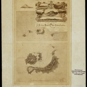


Isles de Banda = Eylanden van Banda
c.1772-1780
Indonesia
Map of the Banda Islands—which was at this time the only source of nutmeg in the world—featuring mountains, plantations, settlements and a military fort. On the island of Goenong Api (Banda Api) a volcano erupts (‘api’ means ‘fire’ in Indonesian).


Insvlarvm Bandanensivm: novißima delineatio
c.1680-1709
Indonesia
A navigation map of the Banda Islands marked with bathymetry (sea depth), shoals and anchor points. On the island of Goenonghapy (Banda Api), a volcano erupts (‘api’ means ‘fire’ in Indonesian), and there is a military fort (‘Campa Nga’) on Nera.
- Filter from 1680 to 1871
- Banda Api5
- [remove]Banda Besar5
- [remove]Banda Islands5
- Banda Neira5
- Maluku Islands5
- Banda Sea2
- Gunnanapi2
- Iles de Banda2
- Lonthoir2
- Banda Eilanden1
- Banda Zee1
- Geonong Api1
- more Detailed Location »
- [remove]Jungle/Wooded Area5
- Mountain/Volcano5


