
Search Results


Mar di India
1619
Brunei, Cambodia, East Timor, Indonesia, Laos, Malaysia, Myanmar, Philippines, Singapore, Southeast Asia, Thailand, Vietnam
An early map of Southeast Asia featuring a rhumbline network, a web of lines to help plot routes and aid navigation. Where the lines meet, there is a compass rose with an arrow pointing north. The map is decorated with illustrations of sea monsters.

Indiae Orientalis nova descriptio
c.1633-1636
Brunei, Cambodia, East Timor, Indonesia, Laos, Malaysia, Myanmar, Philippines, Singapore, Southeast Asia, Thailand, Vietnam
The outline of the island of New Guinea is very vague on this early 17th century map of Southeast Asia. The cartouche is decorated with two figures of Asian warriors: one holds a spear, the other a sword. There are also drawings of mermaids.

Mar di India
1644
Brunei, Cambodia, East Timor, Indonesia, Laos, Malaysia, Myanmar, Philippines, Singapore, Southeast Asia, Thailand, Vietnam
This mid-17th century map of Southeast Asia is from Isaac Commelin’s book describing the voyages of the Dutch East India Company ‘Begin ende voortgangh…’. There is an inset map of the island of Botton (Buton Island, southeast of Celebes (Sulawesi)).

India quae Orientalis dicitur, et insvlae adiacentes
c.1645-1658
Brunei, Cambodia, East Timor, Indonesia, Laos, Malaysia, Myanmar, Philippines, Singapore, Southeast Asia, Thailand, Vietnam
German text on the reverse of this map describes the populations, crops, trade etc. of Sumatra, Borneo, Philippines, and Banda Islands. There are drawings of sailing ships, and the map is dedicated to the Dutch merchant Christophoro Thisio.

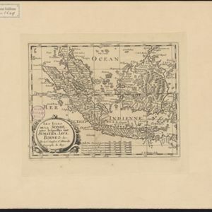
Les Isles de la Sonde: entre lesquelles sont Sumatra, Java, Borneo &c.
1652
Brunei, Indonesia, Malaysia, Singapore
This mid-17th century map of the Sunda Isles (‘Isles de la Sonde’) includes the Malay Peninsula in addition to Sumatra, Java and Borneo. Mountain ranges and jungles are shown pictorially, and the islands and coasts feature shoals and reefs.
Les Isles de la Sonde: entre lesquelles sont Sumatra, Java, Borneo &c.
c.1652
Brunei, Indonesia, Malaysia, Singapore
This mid-17th century map of the Sunda Isles (‘Isles de la Sonde’) includes the Malay Peninsula in addition to Sumatra, Java and Borneo. Mountain ranges and jungles are shown pictorially, and the islands and coasts feature shoals and reefs.
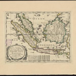
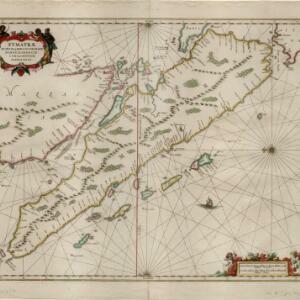
Svmatrae et insularum locorumque nonnullorum circumiacentium tabula noua
c.1657-1680
Indonesia, Malaysia, Singapore
Mountains and jungles are shown pictorially on this map of Sumatra and surrounding islands. The cartouche is decorated with Asian warriors; the scale with cherubs playing with cartography tools. From Jan Jansson’s Latin edition of ‘Atlas Maritimus’.

India quae Orientalis dicitur, et insvlae adiacentes
1664
Brunei, Cambodia, East Timor, Indonesia, Laos, Malaysia, Myanmar, Philippines, Singapore, Southeast Asia, Vietnam, Thailand
A map of Asia decorated with colourful illustrations including two men in ‘eastern’ clothing, the Greek goddess Athena with a coat of arms and a knight in armour, and cherubs playing with cartography tools: a globe, compass, and pair of callipers.
- Filter from 1581 to 1883
- [remove]Malay Peninsula68
- Sumatra66
- Borneo59
- Java58
- Sulawesi53
- Celebes40
- Western New Guinea40
- Malacca39
- Siam39
- Pegu36
- Maluku Islands29
- Sunda Islands26
- more Detailed Location »
- [remove]Jungle/Wooded Area68
- Mountain/Volcano68
- Wild Animals15
- Wetlands4
- Mangrove2


