
Search Results


Topographische Kaart der residentie Bantam
1897
Indonesia
The residency of Bantam, West Java, shown over nine sheets. Coffee and tea plantations, fields of rice, alang-alang, bamboo and other crops are marked. Inset maps show distances by road and path, and the area divided into regencies and districts.

Kaiser Wilhelms-Land: Das Hinterland der Astrolabe-Bucht bis zum Ramu-Fluss
1896
Papua New Guinea
Map of part of the north coast of Kaiser-Wilhelmsland (German New Guinea) spread over two sheets. It focuses on rivers, noting width, depth, temperature, currents, vegetation etc.; and on mountains, showing heights and side views (elevations).

Sketch map shewing the rivers and an outline of the coast... Gulf of Papua, British New Guinea
1893
Papua New Guinea
Map of part of the east coast of the Gulf of Papua, with river mouths, shoals, bathymetry (water depth). On land, notes on terrain (‘Hills 100 to 150 ft. high’), land (‘Good soil’), vegetation (‘Nipa and Sago Palms’) and people (‘Ipikoi Tribe’).

Sketch map of the head of Collingwood Bay
1892
Papua New Guinea
Map of Collingwood Bay, north coast of New Guinea, with bearings to mountains, bathymetry (sea depth), shoals and reefs. On land, notes on terrain (‘sloping plains’, ‘Stiff clay soil’), vegetation (‘Casuarina trees’) and people (‘FRIENDLY TRIBE’).

Map of British New Guinea
1892
Papua New Guinea, Indonesia
Map of British New Guinea, focusing on the sea (islands, shoals, reefs), coast (settlements, bays), mountains and land (‘dense forest’, ‘timbered with Eucalyptus’). Inset maps of Port Moresby, Samarai Island, and the whole island of New Guinea.

Schutzgebiet der Neu-Guinea-Kompanie
c.1892-1893
Indonesia, Papua New Guinea
Very detailed six-sheet map of eastern New Guinea, with numerous inset maps of bays and islands, and other inset maps covering ethnography, explorers of the region, marine routes across the Pacific Ocean, cannibalism, missionaries activity etc.

Rough Sketch of 200 miles of the western portion of British New Guinea, including rivers
1890
Papua New Guinea
Map of British New Guinea with notes on the terrain (‘Low country’), vegetation (‘Mangrove, Nipa and Fan Palms’), crops (‘Small plantations Sugar cane & Taro’), coastal features (‘Coral and Sand flats) and people (‘Friendly tribe’, ‘Dariamo Tribe’).


Map of part of south-east New Guinea embracing its northern and southern waters
1889
Papua New Guinea
This map focuses on the southern coast including the capital Port Moresby, with the northern regions left mostly blank. There are four inset drawings of side views of mountains (elevations), and the border with German New Guinea is marked.

Sketch Map of Mai Cussa or Baxter River, and Wasu Cussa or Chester River, with their tributaries
1888
Papua New Guinea
Map of an expedition along two rivers on the southern coast of British New Guinea, with notes of terrain (‘Undulating country’), vegetation (‘Coconut Palms’) and wildlife (‘Flying Foxes’). More details have been added by hand (‘Ridge about 10ft.’).
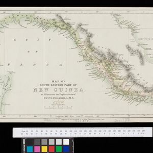
Map of South Eastern part of New Guinea: to illustrate the explorations of Rev. J. Chalmers, L.M.S.
1887
Papua New Guinea
Map of the southeast coast of British New Guinea, divided into administrative regions, with the northern regions left mostly blank. Based on the explorations of the Scottish missionary James Chalmers.


