Search

Search Results

Borneo Insula

eventc.1600-1699

location_onMalaysia, Indonesia

An early map of the island of Borneo, depicting the natural landscape of mountains, forests, rivers and shoals, and also evidence of human habitation with houses representing settlements, and a port and shipping route along the northern coast.

[Sumatra]

event1581

location_onIndonesia

This early map of Sumatra—referred to in the accompanying French text as ‘Isle de la Taprobane’—is covered with illustrations of people working on the land, and with elephants and camels. Villages, mountains, rivers and wild animals are also shown.

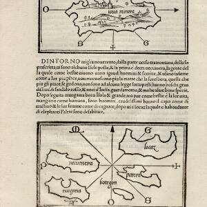
[Java Minor and map of Necumera, Locaz, Patera, Botegon, Mangama]

event1547

location_onThailand, Indonesia

Taken from Benedetto Bordone's ‘Isolario [The Book of Islands]’, these pages contain two maps: one of Sumatra (‘Iaua Minore’), and one of a group of five unknown islands (Locaz is thought to possibly be Thailand).

close