Search

Search Results

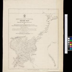
British New Guinea: Sketch plan showing the route traversed by His Excellency Sir Wm. Macgregor... from the Mambre mouth to the village of Gosisi on the Vanapa

event1897

location_onPapua New Guinea

Map of the Mambare River from Mount Victoria to the sea at Duvira (or Traitors) Bay, British New Guinea. Villages, bases, camps and stores are marked, and there are notes on terrain (‘Low Hills’), vegetation (‘Betal Palms’), river width, rapids etc.

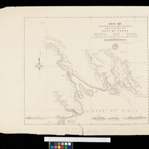
Sketch map shewing the rivers and an outline of the coast... Gulf of Papua, British New Guinea

event1893

location_onPapua New Guinea

Map of part of the east coast of the Gulf of Papua, with river mouths, shoals, bathymetry (water depth). On land, notes on terrain (‘Hills 100 to 150 ft. high’), land (‘Good soil’), vegetation (‘Nipa and Sago Palms’) and people (‘Ipikoi Tribe’).

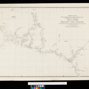
Sketch map shewing the rivers and an outline of the coast... Gulf of Papua, British New Guinea

event1892

location_onPapua New Guinea

Map of part of the west coast of the Gulf of Papua, with islands, river mouths, shoals, bathymetry (water depth), notes to aid navigation. On land, notes on terrain (‘Limestone Hill’), vegetation (‘Pandanus & Nipa Palms’) and people (‘Paia Tribe’).

New Sketch Map of the Protected Malay State of Perak

event1892

location_onMalaysia

Map of the state of Perak (Malay Peninsula) with a table of statistics: area, population, road/railway/river lengths, revenue, tin exports. Gold and tin mines are marked, and the Straits Settlements are highlighted in red.

New sketch map of the protected Malay State of Perak

event1892

location_onMalaysia

Map of state of Perak (Malay Peninsula) with a table of statistics: area, population, road/railway/river lengths, revenue, tin exports. Straits Settlements highlighted red. Someone has added handwritten travel times/distances by steamer/road/train.

Rough Sketch of 200 miles of the western portion of British New Guinea, including rivers

event1890

location_onPapua New Guinea

Map of British New Guinea with notes on the terrain (‘Low country’), vegetation (‘Mangrove, Nipa and Fan Palms’), crops (‘Small plantations Sugar cane & Taro’), coastal features (‘Coral and Sand flats) and people (‘Friendly tribe’, ‘Dariamo Tribe’).

Singapore: Plan of harbour and roadstead

event1885

location_onSingapore

Plan of Singapore harbour, with wharfs and buildings. A roadstead—a body of water sheltered from tides/currents, for ships to anchor—is labelled ‘Singapore Road’. Islands, shoals and reefs are marked, as are roads and buildings in the city.

Map of the Malay Peninsula

event1883

location_onMalaysia, Singapore

The Straits Settlements are in red, with the rest of the map marked with names of local peoples (‘Inhabited by the Johor Jakuns’) and resources (mines). Many areas are left blank or vague as unexplored or approximate. Inset map of Singapore city.

Map of Prince of Wales' Island or Pulo Penang and province Wellesley

event1853

location_onMalaysia

Map of the Penang Strait, including written instructions on how to navigate the strait. On land, areas of cultivation are marked, with a table listing acreage used for each crop. A boundary with Siam based on an 1831 treaty is also shown.

Singapore harbours and roads with the adjacent channels

event1840

location_onSingapore

An early 19th century map of Singapore’s southern coast and islands, with bathymetry (sea depth), shoals and reefs, anchor points, and notes to aid navigation. The roads and main buildings of Singapore city are also shown.

close

  • Filter from 1840 to 1897

Current results range from 1840 to 1897