
Search Results


Kaiser Wilhelms-Land: Das Hinterland der Astrolabe-Bucht bis zum Ramu-Fluss
1896
Papua New Guinea
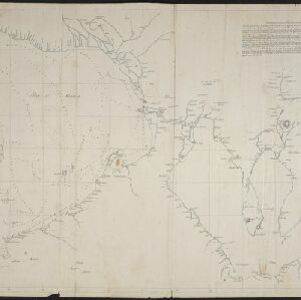
Map of part of the north coast of Kaiser-Wilhelmsland (German New Guinea) spread over two sheets. It focuses on rivers, noting width, depth, temperature, currents, vegetation etc.; and on mountains, showing heights and side views (elevations).

Sketch map shewing the rivers and an outline of the coast... Gulf of Papua, British New Guinea
1893
Papua New Guinea
Map of part of the east coast of the Gulf of Papua, with river mouths, shoals, bathymetry (water depth). On land, notes on terrain (‘Hills 100 to 150 ft. high’), land (‘Good soil’), vegetation (‘Nipa and Sago Palms’) and people (‘Ipikoi Tribe’).

Map of the River of Don-nai from Cape St. James to the city of Saigon
1820
Vietnam
A map to aid in the navigation of the rivers leading to Saigon (Ho Chi Minh City, Vietnam). Details include bathymetry (water depth), currents, and a side view (or ‘elevation’) of hills to use as a landmark. Tides are described in written remarks.
[Manuscript map of Manila Harbor and Bay Lake]
1810
Philippines
This early 19th century hand-drawn map of Manila Bay has detailed instructions in Spanish on how to enter the bay, and the port at Cavite. Bathymetry (water depth), the mouths of rivers, and landmark mountains are shown to aid navigation.


