Search Results
![](https://historicalmaps.yale-nus.edu.sg/rails/active_storage/representations/eyJfcmFpbHMiOnsibWVzc2FnZSI6IkJBaHBBbW9DIiwiZXhwIjpudWxsLCJwdXIiOiJibG9iX2lkIn19--1c5ba0ed0257fddc2d7b10d928231a0510939d49/eyJfcmFpbHMiOnsibWVzc2FnZSI6IkJBaDdCam9MY21WemFYcGxTU0lNTkRBd2VETXdNQVk2QmtWVSIsImV4cCI6bnVsbCwicHVyIjoidmFyaWF0aW9uIn19--bc467f5637e8b6d3bfb826116f92b6bfedfbf03a/leiden-2010751.jpeg)
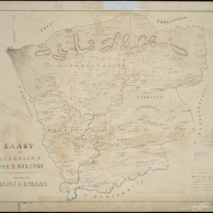
Kaart der afdeeling Poerbolingo: Residentie Banjoemaas
1857
Indonesia
The legend on this hand-drawn map of the district of Poerbolingo (Purbalingga), Central Java, includes ‘hoofd plaats [main town]’, ‘dessa [village]’, ‘doekoeh [farm]’, ‘indigofabriek [indigo plant mill]’ and ‘koffypakhuis [coffee warehouse]’.
![](https://historicalmaps.yale-nus.edu.sg/rails/active_storage/representations/eyJfcmFpbHMiOnsibWVzc2FnZSI6IkJBaHBBb1VCIiwiZXhwIjpudWxsLCJwdXIiOiJibG9iX2lkIn19--cfa4f390617e579f87c278355eaa18e1bce7641d/eyJfcmFpbHMiOnsibWVzc2FnZSI6IkJBaDdCam9MY21WemFYcGxTU0lNTkRBd2VETXdNQVk2QmtWVSIsImV4cCI6bnVsbCwicHVyIjoidmFyaWF0aW9uIn19--bc467f5637e8b6d3bfb826116f92b6bfedfbf03a/leiden-000161.jpeg)
Die Ostindischen Inseln
1846
Brunei, Cambodia, East Timor, Indonesia, Laos, Malaysia, Myanmar, Philippines, Singapore, Southeast Asia, Thailand, Vietnam
Map of Southeast Asia highlighting the colonial possessions of the Netherlands (Dutch East Indies), Spain (Philippines), Britain (Straits Settlements, Burma, part of Borneo) and Portugal (East Timor). From the German atlas ‘Stielers Handatlas’.
![](/assets/maps-default-4437667d48326feaa7d779a3a87e5ce98ace70dc331c4ffc70c99fa98a937ffe.jpg)
Die Ostindischen Inseln
1846
Brunei, Cambodia, East Timor, Indonesia, Laos, Malaysia, Myanmar, Philippines, Singapore, Southeast Asia, Thailand, Vietnam
Map of Southeast Asia highlighting the colonial possessions of the Netherlands (Dutch East Indies), Spain (Philippines), Britain (Straits Settlements, Burma, part of Borneo) and Portugal (East Timor). From the German atlas ‘Stielers Handatlas’.
![](https://historicalmaps.yale-nus.edu.sg/rails/active_storage/representations/eyJfcmFpbHMiOnsibWVzc2FnZSI6IkJBaHBBcWtDIiwiZXhwIjpudWxsLCJwdXIiOiJibG9iX2lkIn19--1bb667deca766faf951132094f8f1153b24a1684/eyJfcmFpbHMiOnsibWVzc2FnZSI6IkJBaDdCam9MY21WemFYcGxTU0lNTkRBd2VETXdNQVk2QmtWVSIsImV4cCI6bnVsbCwicHVyIjoidmFyaWF0aW9uIn19--bc467f5637e8b6d3bfb826116f92b6bfedfbf03a/bodleian-0492.jpeg)
Kaart van de Residentie Bezoeki en de Afdeeling Banjoewangi
1856
Indonesia
Map of the Dutch colonial administrative regions of Bezoeki (Besuki) and Banjoewangi (Banyuwangi), on Java. Includes an elevation view of the mountains. (From ‘Algemeene Atlas van Nederlandsche Indie [General Atlas of the Dutch East Indies]’.)
- Indonesia151
- Malaysia32
- East Timor31
- Singapore30
- Brunei25
- Philippines22
- Thailand11
- Cambodia7
- Laos7
- Myanmar7
- Southeast Asia7
- Vietnam7
- more Simple Location »
- [remove]Dutch East Indies151
- [remove]Java151
- Java Sea41
- Borneo39
- Sumatra39
- Sulawesi35
- Celebes33
- Malay Peninsula29
- Maluku Islands28
- South China Sea27
- Western New Guinea27
- Celebes Sea24
- more Detailed Location »
- Kampong/Village82
- Post Office48
- Residential Area34
- Military Fort23
- Cemetery/Columbarium21
- Temple15
- Church9
- Hospital9
- Mosque8
- Public Space6
- Jail/Prison5
- Well5
- Palace4
- Military Barracks3
- more Settlement Features »
- [remove]Mountain/Volcano151
- Wetlands60
- Jungle/Wooded Area42
- Wild Animals1
- Cronenberg, F.33
- Wolff31
- Versteeg, W.F.26
- Melvill van Carnbee, Pieter21
- Veelwaard, Daniël6
- Böhm5
- Frühling, P.5
- Ostreig5
- more Map Maker »
- Van Haren Noman & Kolff35
- Topographische Inrichting32
- A.J. Bogaerts19
- D. Heyse13
- Topographische Bureau8
- Emrik & Binger7
- Carl Wilhelm Mieling6
- Justus Perthes6
- more Printer/Publisher »
- The Hague55
- Batavia45
- Amsterdam13
- Leiden9
- Brussels6
- Gotha6
- London5
- Breda2
- more Place of Publication »