Search

Search Results

Straat Mangkasar: Blad II

event1898

location_onIndonesia

Late 19th century map of the Makassar Strait between Borneo and Celebes (Sulawesi), with shoals and reefs, bathymetry (sea depth), shipwrecks and other navigation aids marked. On land, mountains, with their heights, and rivers are shown.

Kaart van het eiland Lombok

event1897

location_onIndonesia

Topographic map of the island of Lombok in the Lesser Sunda Islands, with terrain shown by contour lines. Administrative districts, villages, routes, forests and crops (rice, coconut, coffee, banana, alang-alang, bamboo, Javanese pine) are marked.

Kaart van der residentie Soerabaja

event1893

location_onIndonesia

A map of the residency of Soerabaja (East Java) divided into regencies, departments and districts. There are large fishing ponds around the coasts. An inset map shows distances between settlements by road, tracks and paths.

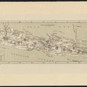
Kaart van den gemiddelden regenval op Java, tevens situatie-schets van de djati- en wildhoutbosschen

event1892

location_onIndonesia

This late 19th century map records the average rainfall at a variety of locations—marked with blue dots—on Java. Three types of forest are also shown: cultivated forest, wild forest under management, and wild forest not under management.

Kaart van het eiland Bawean

event1886

location_onIndonesia

Topographic map of the island of Bawean in the Java Sea, with terrain shown by contour lines, and mountains labelled with their heights. Villages, forests (heavy, light, teakwood) and crops (coconut, coffee, alang-alang, rice, bamboo) are marked.

Topographische kaart der residentie Batavia

eventc.1882-1883

location_onIndonesia

The residency of Batavia, West Java, featuring plantations (coffee, tea, coconut, cinnamon, nutmeg, sugar); crops (rice, alang-alang, bamboo); fishing ponds; factories, warehouses, shops; routes, administrative borders; mountains, rivers, lakes.

Kaart van Java

event1878

location_onIndonesia

Map of Java divided into administrative areas (‘residencies’). Telegraph lines, railways (including those under construction) and postal routes are marked. Around the coasts, the routes of steamships are shown, with journey distances in miles.

Kaart van Java

event1878

location_onIndonesia

Map of Java divided into administrative areas (‘residencies’). Telegraph lines, railways (including those under construction) and postal routes are marked. Around the coasts, the routes of steamships are shown, with journey distances in miles.

Nederlandsch Oost-Indie

event1867

location_onBrunei, East Timor, Indonesia, Malaysia, Philippines, Singapore, Thailand

Map of the Dutch East Indies, divided into administrative regions with coloured borders. There is an inset map of the important port city of Batavia (Jakarta) and its surroundings.

Nederlandsch Oost-Indië

event1865

location_onBrunei, Cambodia, East Timor, Indonesia, Laos, Malaysia, Myanmar, Vietnam, Thailand, Southeast Asia, Singapore, Philippines, Papua New Guinea

This detailed map of the Dutch East Indies in the mid-19th century contains a great deal of information: topographical details, settlements and administrative areas, roads, railways and maritime routes, telegraph lines, inset maps etc.

Die Ostindischen Inseln

event1846

location_onBrunei, Cambodia, East Timor, Indonesia, Laos, Malaysia, Myanmar, Philippines, Singapore, Southeast Asia, Thailand, Vietnam

Map of Southeast Asia highlighting the colonial possessions of the Netherlands (Dutch East Indies), Spain (Philippines), Britain (Straits Settlements, Burma, part of Borneo) and Portugal (East Timor). From the German atlas ‘Stielers Handatlas’.

close

  • Filter from 1830 to 1898

Current results range from 1830 to 1898