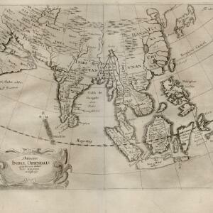
Search

Search Results

Asia

event1814

location_onBrunei, Cambodia, Indonesia, Laos, Malaysia, Myanmar, Philippines, Singapore, Southeast Asia, Thailand, Vietnam

An early 19th century map, with the regions of Southeast Asia marked with coloured borders: Malaya is red, indicating it is part of the British Empire; the orange borders around Sumatra, Borneo and Celebes show they are part of the Dutch East Indies.

East Indies

eventc.1800-1899

location_onBrunei, Cambodia, East Timor, Indonesia, Laos, Malaysia, Myanmar, Philippines, Singapore, Southeast Asia, Thailand, Vietnam

Longitude is indicated in two different ways on this mid-18th century map: along the top border, it is shown in degrees (number of degrees east of London); more unusually, along the bottom border, it is shown in time (number of hours east of London).

East Indies

event1769

location_onBrunei, Cambodia, East Timor, Indonesia, Laos, Malaysia, Myanmar, Philippines, Singapore, Southeast Asia, Thailand, Vietnam

Longitude is indicated in two different ways on this mid-18th century map: along the top border, it is shown in degrees (number of degrees east of London); more unusually, along the bottom border, it is shown in time (number of hours east of London).

Carte des Indes Orientales

event1748

location_onBrunei, Cambodia, East Timor, Indonesia, Laos, Malaysia, Myanmar, Philippines, Singapore, Southeast Asia, Thailand, Vietnam

This mid-18th century map features a label noting that the Byayos people inhabited the mountains of central Borneo. Another note at the northeast tip of Borneo states that the location and number of islands in the area is uncertain.

Nuova carta dell' India di là del Fiume Ganges overo di Malacca, Siam, Cambodia, Chiampa, Kochinchina, Laos, Pegu, Ava &c.

event1740

location_onBrunei, Cambodia, Indonesia, Laos, Malaysia, Myanmar, Singapore, Thailand, Vietnam, Southeast Asia

Based on a map by Guillaume Delisle, this map of Southeast Asia shows mountains and settlements pictorially, with larger cities also coloured red. Regional borders are colour-coded, as are some internal borders on the Malay Peninsula.

India orientalis, cum adjacentibus insulis

event1740

location_onBrunei, Cambodia, East Timor, Indonesia, Laos, Malaysia, Myanmar, Philippines, Singapore, Southeast Asia, Thailand, Vietnam

This mid-18th century map of Asia features a drawing of religious imagery: Asian people are seen making offerings to two figures, including the Greek god Poseidon (or the Roman god Neptune), and kneeling as cherubs descend from the sky.

L'Asie dressée sur les observations de Mrs. de l'Academie Royale de Sciences

event1730

location_onBrunei, Cambodia, East Timor, Indonesia, Laos, Malaysia, Myanmar, Philippines, Singapore, Southeast Asia, Thailand, Vietnam

This map features maritime routes: between Siam and Batavia; and five routes of the explorers Juan Gaetan and Olivier du Nord (dated 1542) east of the Philippines. The cartouche has a colourful illustration of Asian people in traditional costume.

Asiae recentissima delineatio, qua Status et Imperia totius Orientis unacum Orientalibus Indiis exhibentur

event1730

location_onVietnam, Myanmar, Papua New Guinea, Philippines, Singapore, Southeast Asia, Thailand, Malaysia, Laos, Indonesia, East Timor, Cambodia, Brunei

This map's cartouche features an illustration of three men bowing before a ruler on a throne. There is also what was probably meant to be a lion, though the poor likeness suggests it was based on written descriptions rather than real life experience.

Asiæ in tabula geographica delineatio

event1720

location_onBrunei, Cambodia, Indonesia, East Timor, Malaysia, Myanmar, Philippines, Singapore, Laos, Southeast Asia, Thailand, Vietnam, Papua New Guinea

This colourful early 18th century map shows Asia along with part of Europe and Africa. It is decorated with a painting of Asian traders negotiating over a sale of carpets, while three lions, a ship and city walls complete the picture.

A map of the East-Indies and the adjacent countries: with the settlements, factories and territories, explaining what belongs to England, Spain, France, Holland, Denmark, Portugal &c.

event1717

location_onBrunei, Cambodia, East Timor, Indonesia, Laos, Malaysia, Myanmar, Philippines, Singapore, Southeast Asia, Thailand, Vietnam

This map showcases the colonial territories of Southeast Asia in the 18th century, with text detailing trading information and the products of each region. There are five inset maps featuring plans of specific trading ports.

Asiae recentissima delineatio, qua Status et Imperia totius Orientis unacum Orientalibus Indiis exhibentur

event1716

location_onVietnam, Myanmar, Papua New Guinea, Philippines, Singapore, Southeast Asia, Thailand, Malaysia, Laos, Indonesia, East Timor, Cambodia, Brunei

This map's cartouche features an illustration of three men bowing before an enthroned ruler. A second image is of a procession where a horned four-armed humanoid creature is being carried on poles by two bearers, while musicians follow behind.

Delineatio Indiæ orientalis: quae lumen dabit huic itinerario et historiis

event1700

location_onBrunei, Cambodia, Indonesia, Laos, Malaysia, Myanmar, Philippines, Singapore, Southeast Asia, Thailand, Vietnam

This map of India and Southeast Asia—or ‘Indiae Orientalis [East Indies]’ as it was called at the time—was published in a book documenting the travels of the German scholar and geographer Adam Olearius (1599–1671).

close

  • Filter from 1540 to 1814

Current results range from 1540 to 1814