
Search Results
26 Results found

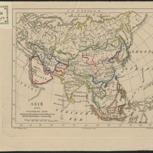
Azië : 1861
1861
Brunei, Cambodia, East Timor, Indonesia, Laos, Malaysia, Myanmar, Papua New Guinea, Philippines, Singapore, Southeast Asia, Thailand, Vietnam
Map of Asia published by the North Holland Regional Association of the Dutch Teachers' Association. Mainland Southeast Asia is labelled ‘Achter Indie [Beyond India]’; the Indonesian Archipelago is labelled ‘Indische Archipel [Indian Archipelago]’.

Accuratissima totius Asiæ tabula: In omnes partes divisa
1750
Brunei, Cambodia, East Timor, Indonesia, Laos, Malaysia, Myanmar, Philippines, Singapore, Southeast Asia, Thailand, Vietnam
A detailed late 17th century map of Asia, showing ancient kingdoms and the place names of important settlements. The cartouche features a drawing of Asian traders selling their goods, while a camel, monkey and two birds look on.
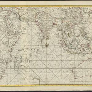
Tabula Indiæ Orientalis et regnorum adjacentium
1724
Brunei, Cambodia, East Timor, Indonesia, Laos, Malaysia, Myanmar, Philippines, Singapore, Southeast Asia, Thailand, Vietnam
Colourful map of the East Indies focusing on maritime navigation: there is a compass rose at the centre of a rhumbline network (a web of lines to help plot routes). Shoals, reefs and islands are also marked.

Asiæ in tabula geographica delineatio
1720
Brunei, Cambodia, Indonesia, East Timor, Malaysia, Myanmar, Philippines, Singapore, Laos, Southeast Asia, Thailand, Vietnam, Papua New Guinea
This colourful early 18th century map shows Asia along with part of Europe and Africa. It is decorated with a painting of Asian traders negotiating over a sale of carpets, while three lions, a ship and city walls complete the picture.

Asia
c.1710
Brunei, Cambodia, East Timor, Indonesia, Laos, Malaysia, Myanmar, Philippines, Singapore, Southeast Asia, Thailand, Vietnam
The illustration on this map highlights the wealth of the Asian trade routes, with merchants wearing elaborate robes presenting valuable treasures to a royal figure. A monkey, tortoise and camel emphasise the ‘exoticism’ of Asia.

Insularum Indiæ orientalis nova descriptio
c.1700
Brunei, Cambodia, East Timor, Indonesia, Laos, Malaysia, Myanmar, Philippines, Singapore, Southeast Asia, Thailand, Vietnam
The outline of the island of New Guinea is very vague on this early 17th century map of Southeast Asia. The cartouche is decorated with two figures of Asian warriors: one holds a spear, the other a sword. There are also drawings of mermaids.
- Filter from 1596 to 1867
- Brunei26
- East Timor26
- [remove]Indonesia26
- Malaysia26
- Philippines26
- Singapore26
- Thailand26
- Cambodia24
- Laos24
- Myanmar24
- Southeast Asia24
- Vietnam24
- more Simple Location »
- Borneo26
- [remove]Siam26
- [remove]Sulawesi26
- Sumatra26
- [remove]Western New Guinea26
- Java25
- Malay Peninsula24
- Celebes23
- Pegu22
- Malacca20
- Insulae Philippinae15
- Iava14
- more Detailed Location »
- River26


