
Search Results


Ankerplaatsen en mondingen van rivieren op de Noord- en Oostkust van Sumatra: Blad I
1896
Indonesia
Eleven separate maps of bays and river mouths of Sumatra, including two bays on the island on Bras (Breueh Island), and the bay at Kota Radja (Banda Aceh). Bathymetry (sea depth), anchor points, reefs and shoals are marked, along with tide data.

Chart of the China Sea
1864
Papua New Guinea, Indonesia, Malaysia, Cambodia, East Timor, Philippines, Singapore, Thailand, Vietnam
To aid navigation, this map shows small islands, shoals and reefs, maritime routes for use during monsoons or at particular times of the year, bathymetry (sea depth), tide information, shipwrecks, compass roses and landmark mountains at the coasts.
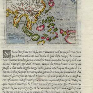
Indiae Orientalis insularumque adiacientium typus
c.1596-1640
Brunei, Cambodia, East Timor, Indonesia, Laos, Malaysia, Myanmar, Philippines, Singapore, Southeast Asia, Thailand, Vietnam
Rivers and major settlements are the main feature of this colourful early map of Asia. Italian text gives further details about the region.


