
Search Results
Filter
Land Features
Mountain/Volcano
Remove constraint Land Features: Mountain/Volcano
Detailed Location
Upper Burma
Remove constraint Detailed Location: Upper Burma
Printer/Publisher
Survey of India Offices, Calcutta
Remove constraint Printer/Publisher: Survey of India Offices, Calcutta
14 Results found


Portion of coal fields tract: Upper Chindwin district
1892
Myanmar
A map surveying coal fields close to the Chindwin River in Upper Burma (Myanmar). Mountains are shown by using hachures: short lines/dashes that give a sense of the shape and steepness of terrain. Survey stations are marked with their height.
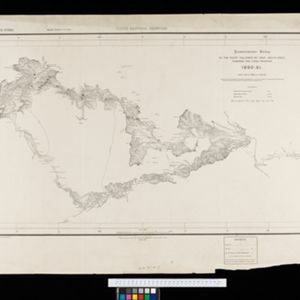
South eastern frontier: Reconnaissance survey of the route followed by Lieut. Daly's party towards the China frontier
c.1890-1891
Myanmar
A map of the route of a British Army expedition near the border of Upper Burma with China. High points are marked with their heights so they can be used for triangulation. Settlements, rivers, trade routes and footpaths are also shown.


