
Search Results


Algemeene kaart van Nederlandsch Oostindie
c.1839-1855
East Timor, Indonesia, Malaysia, Singapore
This map of the Dutch East Indies is spread over eight sheets, with a hand-drawn cover sheet showing the whole area. There are numerous inset maps of islands, bays, cities etc. Two of the inset maps have a replacement map pasted over them.


Topographische kaart der residentie Bagelen
1860
Indonesia
The residency of Bagelen, Central Java, is shown divided into regencies and districts. Coffee, tea and cinnamon plantations, fields of rice, alang-alang and other crops, mountains, rivers, hot and mineral springs, settlements and routes are marked.


Nederlandsch Oost-Indië
1865
Brunei, Cambodia, East Timor, Indonesia, Laos, Malaysia, Myanmar, Vietnam, Thailand, Southeast Asia, Singapore, Philippines, Papua New Guinea
This detailed map of the Dutch East Indies in the mid-19th century contains a great deal of information: topographical details, settlements and administrative areas, roads, railways and maritime routes, telegraph lines, inset maps etc.

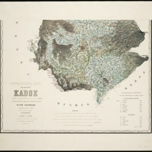
Topographische kaart der residentie Kadoe
1870
Indonesia
The residency of Kadoe (Kadu), Central Java, is shown divided into regencies and districts, with population figures for each district. Villages (kampongs) and towns, fields, mountains, rivers and roads are marked. There is an inset triangulation map.

Topographische kaart der residentie Semarang
c.1869-1871
Indonesia
The residency of Semarang, Central Java, featuring crops (coffee, rice, bamboo, nipa palm); warehouses, cemeteries, post offices; routes, administrative borders; mountains, rivers, forests. An inset map shows updated details of the Kendal district.


