
Search Results


Chart of the China Sea
1864
Papua New Guinea, Indonesia, Malaysia, Cambodia, East Timor, Philippines, Singapore, Thailand, Vietnam
To aid navigation, this map shows small islands, shoals and reefs, maritime routes for use during monsoons or at particular times of the year, bathymetry (sea depth), tide information, shipwrecks, compass roses and landmark mountains at the coasts.


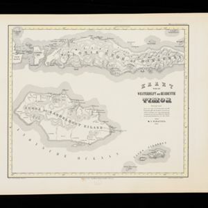
Kaart van de Oosterhelft der Residentie Palembang
1860
Indonesia
Map of the eastern half of the Dutch colonial administrative region (residency) of Palembang, Sumatra. A fort is marked in the town of Batoeradja. (From ‘Algemeene Atlas van Nederlandsche Indie [General Atlas of the Dutch East Indies]’.)

Kaart van Zuid West Celebes, bevattende de Gouvernements en Bondgenootschappelijke Landen van het Gouvernement Celebes
1860
Indonesia
Map of the South Peninsula of Celebes (Sulawesi). The Spermonde Archipelago in the Makassar Strait is very detailed with islands, shoals, reefs and bathymetry. (From ‘Algemeene Atlas van Nederlandsche Indie [General Atlas of the Dutch East Indies]’.)
Kaart van de Westerhelft der Residentie Timor
1860
Indonesia
Map of the western half of the Dutch colonial administrative region (residency) of Timor, featuring Flores, Komodo, Sumba and Savu islands, and their straits. (From ‘Algemeene Atlas van Nederlandsche Indie [General Atlas of the Dutch East Indies]’.)

Kaart van de Westerhelft der Residentie Samarang
1858
Indonesia
Map of the Dutch colonial administrative region (residency) of Samarang (Semarang, Java), with post offices and routes, a saw mill and a sugar factory marked. (From ‘Algemeene Atlas van Nederlandsche Indie [General Atlas of the Dutch East Indies]’.)

Kaart van de Oosterhelft der Residentie Rembang
1858
Indonesia
Map of the eastern half of the Dutch colonial administrative region (residency) of Rembang, Java. A sugar factory and tobacco establishment are marked. (From ‘Algemeene Atlas van Nederlandsche Indie [General Atlas of the Dutch East Indies]’.)


Kaart van de Residentie Madoera en Onderhoorige Eilanden
1858
Indonesia
Map of the Dutch colonial administrative region of the island of Madoera (Madura), featuring bathymetry (sea depth), and an inset map of the Kangean Islands. (From ‘Algemeene Atlas van Nederlandsche Indie [General Atlas of the Dutch East Indies]’.)

Arracan: chart of the entrance to the river
1858
Myanmar
This navigation map of the mouth of the Kaladan River on the west coast of Arracan (modern Myanmar) features drawings of coastal features (elevations), bathymetry (sea depth), shoals and reefs, landmarks, and notes on how to enter the river safely.

Asiatic archipelago
1858
Vietnam, Myanmar, Papua New Guinea, Philippines, Singapore, Southeast Asia, Thailand, Malaysia, Laos, Indonesia, East Timor, Cambodia, Brunei
This late 19th century map of Southeast Asia shows the best maritime routes around the region, according to the time of year. There are also inset maps highlighting the rivers and southern islands of Singapore, and the sea depth around Labuan Island.
- Filter from 1650 to 1900
- [remove]Bathymetry142
- [remove]Maritime Route142
- Tide Data29
- Current Data11
- [remove]Mountain/Volcano142
- Wetlands51
- Jungle/Wooded Area18
- Mangrove5


