Search

Search Results

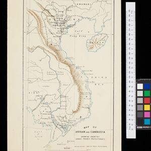
Map of part of south-east New Guinea embracing its northern and southern waters

event1889

location_onPapua New Guinea

This map focuses on the southern coast including the capital Port Moresby, with the northern regions left mostly blank. There are four inset drawings of side views of mountains (elevations), and the border with German New Guinea is marked.

Malay, or East Indian Archipelago, with Burmah, Siam &c.

event1887

location_onBrunei, Cambodia, East Timor, Indonesia, Laos, Malaysia, Myanmar, Philippines, Singapore, Southeast Asia, Thailand, Vietnam

On this map of Southeast Asia, numerous small islands, shoals and reefs are marked and named, especially in the South China Sea and around the Sunda and Maluku islands. Submarine cables to carry telegraph messages around the region are also shown.

[Map of India]

event1887

location_onMyanmar

This four-sheet map of India—featuring an inset map of Burma (Myanmar) —was created for use in Indian schools by Devendranath Dhar, a self-taught Calcutta-based mapmaker. He sent it to the Royal Asiatic Society for advice on publication.

India, Burmah and the adjacent parts of Beluchistan, Afghanistan, Turkestan, the Chinese Empire, and Siam

event1887

location_onMyanmar, Thailand, Malaysia, Indonesia

British Burma is shown on the right of this two-sheet map of India. The green areas had come under British rule after the first and second Anglo-Burmese wars, with Upper Burma (light brown) being incorporated after the Third Anglo-Burmese War (1885).

Kaart van de afdeeling, eiland Saleijer (Silaijara)

event1886

location_onIndonesia

Map of Saleijer (Selayar)—an island off the south coast of Celebes (Sulawesi)—and nearby islands. Settlements and roads are shown, including a long road along the west coast which links cities marked with a Dutch flag, illustrating colonial rule.

W. & A.K. Johnston's sheet of maps to illustrate the Caroline islands dispute between Germany and Spain

event1885

location_onSoutheast Asia, Papua New Guinea, Indonesia, Philippines, Malaysia, East Timor

Three maps of the Caroline Islands. One shows colonised areas in Southeast Asia: Dutch East Indies; British North Borneo, British New Guinea; German New Guinea; Philippines (Spain); Portuguese Timor. The route of the Challenger expedition is marked.

Sketch of Hué

event1885

location_onVietnam

Map of the city of Hué (Huế) on the Perfume River, east coast of Vietnam. There are forts, villages and rice fields along the river. In the city, there is the royal palace within walls and a moat, French military barracks and other colonial areas.

Map of Annam and Cambodia showing country under French protectorate

event1885

location_onCambodia, Laos, Thailand, Vietnam

Map showing the French protectorate territories of mainland Southeast Asia: Annam, Tongking and French Cochin China (modern Vietnam) and Cambodia. Some parts of Siam (Thailand) and Laos are also shown.

Reduzirte Karte von den Philippinen und den Sulu Inseln

event1884

location_onPhilippines, Malaysia, Indonesia

Maritime map of the Philippines, with inset maps of bays showing bathymetry (sea depth), shoals, reefs and anchor points. There is also an inset map of Taal Volcano, and elevations (side views of terrestrial landmarks like mountains and islands).

Itinéraires de Mr A. Pavie dans le Sud-Ouest l'Indo-Chine Orientale (Cambodge et Siam) (1880-1884)

event1884

location_onThailand, Cambodia

The routes taken by the French civil servant and explorer Auguste Pavie are marked on this map of Siam (Thailand) and Cambodge (Cambodia), along with the telegraph line that he subsequently constructed from Pnom Penh (Phnom Penh) to Bangkok.

Map of South-Eastern Asia and Northern Australia: showing the districts in Annam and Tonquin which France proposes to annex and to place under a Protectorate, the portion of New Guinea proposed to be acquired by Queensland, and the districts affected by the volcanic eruptions in Java

event1883

location_onSoutheast Asia, Singapore, Thailand, East Timor, Vietnam, Brunei, Cambodia, Indonesia, Laos, Malaysia, Myanmar, Papua New Guinea, Philippines

This 1883 map shows European colonial territories in Southeast Asia. An inset map details the proposed French annexation of Tonquin, Annam and Cochin China (modern Vietnam). International telegraph lines are also marked.

Kaart van het terrein des oorlogs in Groot-Atjeh

event1883

location_onIndonesia

The Aceh War (1873–1904) between the Sultanate of Aceh and Dutch colonists is highlighted on this map of Groot-Atjeh in 1876. Flag symbols mark the locations of Dutch military posts, and some villages are described as ‘verbrande [burnt]’.

close