
Search Results

Sumatra ein grosse Insel: so von den alten Geographen Taprobana genennet worden
c.1588-1628
Indonesia, Malaysia, Singapore, Thailand
A map of Sumatra featuring villages, mountains and rivers; text describing the island; and a drawing of a man riding an elephant. The title uses the name ‘Taprobana’ for Sumatra, stating it was a name used by ‘ancient geographers [alten geographen]’.


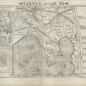
Tabvla Asiae XI
1574
Cambodia, Indonesia, Malaysia, Laos, Myanmar, Singapore, Thailand, Vietnam, Southeast Asia
Mid-16th century map by Girolamo Ruscelli, based on the work of 2nd century geographer Ptolemy. It is difficult to pinpoint exact locations, but the Malay Peninsula is recognisable. Italian text on the reverse describes the region.
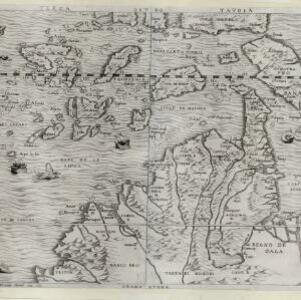
Terza Tavola
1565
Brunei, Cambodia, East Timor, Indonesia, Laos, Malaysia, Myanmar, Philippines, Singapore, Southeast Asia, Thailand, Vietnam
South is orientated towards the top of this map, with maritime Southeast Asia in the upper half and the mainland below. Top right is Java (‘Iava Magiore [Java Major]’); Borneo is labelled ‘Iava Menore [Java Minor]’. Ships and sea monsters are at sea.

Tabvla Asiae XI
1561
Cambodia, Indonesia, Malaysia, Laos, Myanmar, Singapore, Thailand, Vietnam, Southeast Asia
Mid-16th century map by Girolamo Ruscelli, based on the work of 2nd century geographer Ptolemy. It is difficult to pinpoint exact locations, but the Malay Peninsula is recognisable. Italian text on the reverse describes the region.
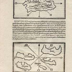
[Java Minor and map of Necumera, Locaz, Patera, Botegon, Mangama]
1547
Thailand, Indonesia
Taken from Benedetto Bordone's ‘Isolario [The Book of Islands]’, these pages contain two maps: one of Sumatra (‘Iaua Minore’), and one of a group of five unknown islands (Locaz is thought to possibly be Thailand).
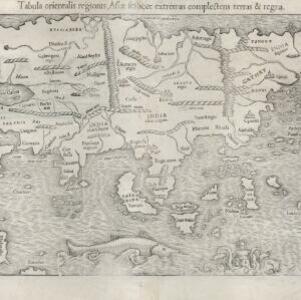
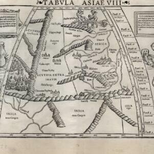
Tabula orientalis regionis, Asiae scilicet extremas complectens terras et regna
1545
Brunei, Cambodia, East Timor, Indonesia, Laos, Malaysia, Myanmar, Philippines, Singapore, Southeast Asia, Thailand, Vietnam
This 1550 map by the German cartographer Sebastian Münster (1488–1552) was based on the work of the 2nd century geographer Ptolemy. There are many inaccuracies, especially in scale and the locations of mountain ranges, but the region is recognisable.
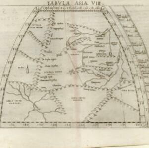
Tabvla Asiae XI
c.1542-1552
Cambodia, Indonesia, Malaysia, Myanmar, Singapore, Thailand, Vietnam, Southeast Asia
Early map by Sebastian Münster, based on the work of 2nd century geographer Ptolemy. The Malay Peninsula—labelled ‘Aurea Chersonesus [Golden Chersonese]’—is recognisable. An illustration shows the local animals: a tiger, cockerels and a white parrot.

India extrema, XIX nova tabvla
1540
Brunei, Cambodia, East Timor, Indonesia, Laos, Malaysia, Myanmar, Philippines, Singapore, Southeast Asia, Thailand, Vietnam
This 1540 map by the German cartographer Sebastian Münster (1488–1552) was based on the work of the 2nd century geographer Ptolemy. On the reverse, there is Latin text giving details of the area, including crops grown.


