
Search Results
994 Results found


Descriptio Malaccae
c.1600-1699
Malaysia, Singapore, Indonesia
Latin text on the reverse of this map describes Malacca, including crops and products (rice, pepper, spices, pearls), precious metals (gold, silver and tin), and animals (sheep, elephant), showing the city’s importance to European trade at the time.

India orientalis
c.1600-1699
Vietnam, Myanmar, Malaysia, Philippines, Singapore, Southeast Asia, Thailand, Laos, Indonesia, Cambodia, Brunei
This 17th century map features a number of mythical lakes once thought to exist in southern China. One of these lakes (‘Chiamai Lac’) feeds three rivers—labelled ‘Menan’, ‘Manthabam’ and ‘Cosmin’—which flow south through mainland Southeast Asia.

Exacta & accurata delineatio cum orarum maritimarum tum etiam locorum terrestrium quae in regionibus China, Cauchinchina, Camboia sive Champa, Syao, Malacca, Aracan & Pegu
1598
Brunei, Cambodia, East Timor, Indonesia, Laos, Malaysia, Myanmar, Philippines, Singapore, Southeast Asia, Thailand, Vietnam
Unusually, north is located to the left of this map of East Asia, rather than the top. The text notes that shallows and reefs are marked, and that the map is based on the explorations of Portuguese ships. Illustrations include sea monsters and ships.

Asia partiṽ̃ orbis maxima MDXCVIII
1598
Brunei, Cambodia, East Timor, Indonesia, Laos, Malaysia, Myanmar, Philippines, Singapore, Southeast Asia, Thailand, Vietnam
The title of this late 16th century map of Asia translates from Latin as 'Asia the largest part of the world'. There is German text on the back of the map giving a description of Asia.

Exacta & accurata delineatio cùm orarum maritimarum tùm etiam locorum terrestrium quae in regionibus China, Cauchinchina, Camboia sive Champa, Syao, Malacca, Aracan & Pegu
1596
Brunei, Cambodia, East Timor, Indonesia, Laos, Malaysia, Myanmar, Philippines, Singapore, Southeast Asia, Thailand, Vietnam
Unusually, north is located to the left of this map of East Asia, rather than the top. The text notes that shallows and reefs are marked, and that the map is based on the explorations of Portuguese ships. Illustrations include sea monsters and ships.
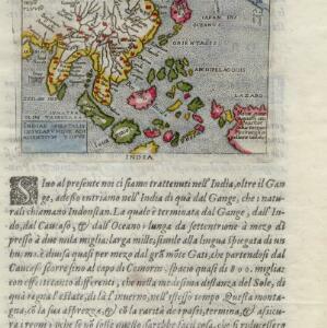
Indiae Orientalis insularumque adiacientium typus
c.1596-1640
Brunei, Cambodia, East Timor, Indonesia, Laos, Malaysia, Myanmar, Philippines, Singapore, Southeast Asia, Thailand, Vietnam
Rivers and major settlements are the main feature of this colourful early map of Asia. Italian text gives further details about the region.

Exacta & accurata delineatio cùm orarum maritimarum tùm etiam locorum terrestrium quae in regionibus China, Cauchinchina, Camboia sive Champa, Syao, Malacca, Aracan & Pegu
1595
Brunei, Cambodia, East Timor, Indonesia, Laos, Malaysia, Myanmar, Philippines, Singapore, Southeast Asia, Thailand, Vietnam
Unusually, north is located to the left of this map of East Asia, rather than the top. The text notes that shallows and reefs are marked, and that the map is based on the explorations of Portuguese ships. Illustrations include sea monsters and ships.
- Filter from 1478 to 1900
- Indonesia818
- Malaysia460
- Singapore395
- Thailand395
- Myanmar392
- Vietnam365
- Cambodia347
- Brunei339
- Laos335
- Philippines327
- East Timor296
- Southeast Asia273
- more Simple Location »
- Port120
- Pier34
- Railway Station34
- River815
- Road305
- Path179
- Railway/Tramway116
- Postal Route85
- Telegraph/Telephone47
- Bridge42
- Canal37
- [remove]Mountain/Volcano994
- Jungle/Wooded Area245
- Wetlands202
- Wild Animals81
- Mangrove23


