Search

Search Results

Kaart der residentie Banjoemas

event1870

location_onIndonesia

The residency of Banyumas (‘Residentie Banjoemas’) in Central Java is shown divided into regencies (yellow borders) and districts (blue borders) on this map. Cities, towns and villages are marked, as are roads, rivers, paths and postal routes.

Topographische kaart der residentie Pekalongan

event1870

location_onIndonesia

Topographic map of the residency of Pekalongan (Central Java), divided into regencies (pink borders) and districts (yellow borders). Mountains, forests, settlements, routes, crops—alang-alang, coffee, sugar, rice—factories and warehouses are shown.

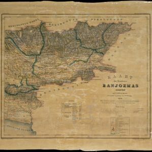
Topographische kaart der residentie Japara

event1870

location_onIndonesia

Four-sheet topographic map of the residency of Japara (Jepara, Central Java), with an inset signal map of locations’ heights and distances. Administrative districts, crops—coffee, alang-alang, rice, sugarcane, coconut—and fishing ponds are shown.

Topographische kaart der residentie Tagal

event1870

location_onIndonesia

The lower half of this two-sheet topographic map of the residency of Tagal (Tegal, Central Java) is dominated by mountains, with the upper half split between forests and rice paddies, and the larger settlements near the coast.

Kaart van den spoorweg van Samarang naar de Vorstenlanden

event1869

location_onIndonesia

This map follows a railway line south from the city of Samarang to Soerakarta and Djokdjokarta (cities in two of the ‘Vorstenlanden’ or ‘Princely Lands’). Other railways, rivers, crops (indigo plants, tobacco, coffee) and sugar factories are marked.

Plattegrond der stad Soerabaija

event1867

location_onIndonesia

A mid-19th century map of the city of Soerabaija (Surabaya, East Java, Indonesia) showing its recently built defences, including the ‘Citadel Prins Hendrik’ fort and a walled moat. Outside the city are villages, plantations and fields.

Plattegrond der stad Batavia

event1866

location_onIndonesia

A mid-19th century map of the important port of Batavia (Jakarta), with its pier, commercial centre and residential streets. However, the city is also surrounded by villages (kampongs), fields and plantations. An inset map shows Batavia Castle.

Plattegrond der stad Samarang

event1866

location_onIndonesia

Mid-19th century map of the city of Samarang (Semarang, Central Java, Indonesia) dominated by the Fort Prins van Oranje. The railway station and Haven Kanal, which flows to the sea, are also prominent. The city is surrounded by villages and fields.

Topographische kaart van de residentie Banjoemaas

event1861

location_onIndonesia

The residency of Banjoemaas (Banyumas), Central Java, featuring plantations (bamboo, teakwood, coconut, coffee, cinnamon) and rice; routes (road, postal), administrative borders; mountains, rivers, wetlands, forests.

Topographische kaart der residentie Bagelen

event1860

location_onIndonesia

The residency of Bagelen, Central Java, is shown divided into regencies and districts. Coffee, tea and cinnamon plantations, fields of rice, alang-alang and other crops, mountains, rivers, hot and mineral springs, settlements and routes are marked.

Kaart van de Westerhelft der Residentie Samarang

event1858

location_onIndonesia

Map of the Dutch colonial administrative region (residency) of Samarang (Semarang, Java), with post offices and routes, a saw mill and a sugar factory marked. (From ‘Algemeene Atlas van Nederlandsche Indie [General Atlas of the Dutch East Indies]’.)

Kaart der Residentie Japara

event1858

location_onIndonesia

Map of the Dutch colonial administrative region (residency) of Japara (Jepara, Java). A cochineal factory—where the dye carmine is made from insects—is shown. (From ‘Algemeene Atlas van Nederlandsche Indie [General Atlas of the Dutch East Indies]’.)

close

  • Filter from 1839 to 1898

Current results range from 1839 to 1898