
Search Results


Kaart der residentie Zuider- en Ooster-afdeeling van Borneo
1899
Indonesia
On this map, the residency of South and East Borneo is divided into departments (green borders) and provinces (yellow borders). There is an inset plan of the city of Banjarmasin, with rivers, buildings, residential areas, roads and crops marked.

Kaart de residentie Wester-afdeeling van Borneo
1898
Indonesia
Topographical map of western Borneo, with inset maps of the islands off the west coast, and of the city of Pontianak including the docks and crops grown near the city (rice, coconut, mangosteen, sago, alang-alang, indigo plant, sugarcane, bamboo).

Kaart van de residentie Wester-afdeeling van Borneo
1898
Indonesia
Topographical map of western Borneo. Larger settlements are marked with their height above sea-level and with a flag to indicate a military garrison. They also have a letter signifying the local ruler, from Sultan to Lauthai (village elder).

Atlas van Nederlandsch Oost-Indië
c.1897-1904
Indonesia
Very detailed atlas of the entire Dutch East Indies, over 16 map sheets, with a cover and overview map. Includes topographic maps, inset maps of cities and islands, and maps featuring land and sea routes, languages, geology, colonial territory etc.

Kaart van den vierkanten paal gouvernements grondgebied te Ngabang
1888
Indonesia
Map of the town of Ngabang, on the Landak River, Borneo and the surrounding forest and mountains. Around the town are cemeteries, a well, a jail and a Chinese temple. Bamboo, coconut trees, fishing ponds and fields (including alang-alang) are marked.


Kaart van den vierkanten paal (I en II) gouvernements grondgebied te Sintang
1888
Indonesia
The Kapoewas (Kapuas) and Melawi rivers converge on this map of the town of Sintang, Borneo. The town lines the river banks, and is surrounded by fields, forest and marshland. Arrows on the rivers mark the direction of their flow.

Kaart van den vierkanten paal gouvernements-grondgebied te Montrado
1887
Indonesia
A map of government land around the town of Montrado, Borneo, a gold mining centre in the 19th century, as shown by the number of gold mines (‘goudmijn’) marked. There are also crops—coconut, alang-alang, bamboo—and agricultural and fish ponds.

Kaart van het Zuidwestelijk gedeelte van het landschap Mampawah, residentie Wester-afdeeling van Borneo
1887
Indonesia
Map of the crops—coconut, alang-alang, rice, nipa palm, bamboo—grown along the Mempawah River (west coast of Borneo). There are also large areas of swampy forest, Malay mosques, shrines and graveyards, and Chinese villages, temples and graveyards.

Nederlandsch Oost-Indië
1865
Brunei, Cambodia, East Timor, Indonesia, Laos, Malaysia, Myanmar, Vietnam, Thailand, Southeast Asia, Singapore, Philippines, Papua New Guinea
This detailed map of the Dutch East Indies in the mid-19th century contains a great deal of information: topographical details, settlements and administrative areas, roads, railways and maritime routes, telegraph lines, inset maps etc.
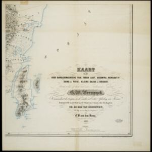
Kaart van het oude Bandjermasinsche rijk, Tanah Laut, Bekompai, Mengkatip, Siong en Patai, Kleine Dajak en Doesoen
1862
Indonesia
A map of the south-eastern tip of Borneo (modern South Kalimantan) spread over four sheets, featuring mountains, wetlands and rivers. Created by the Dutch colonial authorities, small flags mark fortifications of Dutch and auxiliary troops.


