
Search Results


Kaart van het eiland Java uit de nieuwste bronnen zamengesteld
1855
Indonesia
Map of Java divided into administrative areas (‘residencies’ and ‘regencies’). Mountains are represented by hachures, short lines/dashes that give a sense of the shape and steepness of terrain. Postal routes and roads are also marked.

Algemeene Atlas van Nederlandsche Indie
c.1853-1862
Indonesia
Atlas featuring over 60 detailed maps of the Dutch East Indies: 24 maps cover Java; the remainder cover the rest of the Dutch East Indies. There are three index maps. (All the maps in this atlas are also presented separately on this platform.)

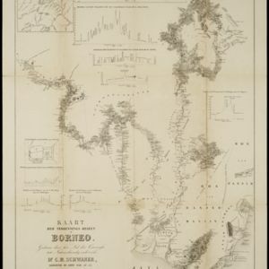
Kaart der verkennings reizen op Borneo
1853
Indonesia
Map charting expeditions in southern and eastern Borneo by the German geologist Carl Schwaner in the 1840s. Includes an inset map of rivers and watersheds in central Borneo, nine cross sections of the heights of rivers, and a plan of a gold mine.


- Filter from 1733 to 1900
- [remove]Dutch East Indies168
- Java80
- Sumatra59
- Batavia28
- Jakarta28
- Aceh22
- Borneo19
- Banda Aceh14
- Celebes14
- Sulawesi14
- Java Sea13
- Kota Radja11
- more Detailed Location »
- [remove]Wetlands168
- Mountain/Volcano131
- Jungle/Wooded Area83
- Mangrove3
- Wild Animals2


