
Search Results
28 Results found


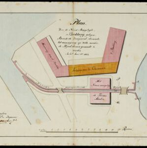
Plan van de nieuw aangelegde bakkerij, gelegen beweste de zaagmool
1812
Indonesia
A plan of a bakery in an unknown location in the Dutch East Indies, next to a proposed water channel (‘rijool’) intended to power a saw mill. There are two additional sheets showing construction drawings of the water channel, with piling underneath.


Caart en waaterpas van het Moolenvliet beneffens de gooten welke aan de oost en westzijde, hun waater uyt het zelve ontfangen
1797
Indonesia
This map shows part of the Moolenvliet canal (now known as Batang Hari) that passes through the centre of Batavia (Jakarta). The Dutch colonial authorities originally dug the canal in the 17th century by diverting part of the Ciliwung river.


A plan of the city and castle of Batavia
1746
Indonesia
A mid-18th century plan of Batavia (Jakarta), the main port of the Dutch East India Company's trading network in Southeast Asia. Ships can be seen transporting goods along ‘The Great River’ to the sea, overseen by Batavia Castle at the river’s mouth.


