
Search Results


Algemeene kaart van Nederlandsch Oostindie
c.1839-1855
East Timor, Indonesia, Malaysia, Singapore
This map of the Dutch East Indies is spread over eight sheets, with a hand-drawn cover sheet showing the whole area. There are numerous inset maps of islands, bays, cities etc. Two of the inset maps have a replacement map pasted over them.
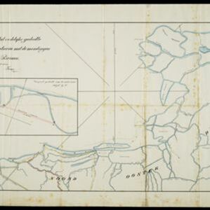
Situatie kaart van het oostelijke gedeelte van de Baai van Batavia met de mondiugen der daar in uitloopende rivieren
1828
Indonesia
A hand-drawn map of the northern part of Batavia Bay, showing rivers and the city of Batavia (Jakarta). An inset map shows a proposed canal designed to join two parts of the Antjol River.


Situatie-kaart van een gedeelte der stad Batavia benevens de bank voor de Groote rivier
1817
Indonesia
Plan of the canals and rivers flowing through the city of Batavia (Jakarta), passing through the port before reaching the pier and the bay. The bay has a sand bank and figures for water depth. There are profile drawings of two of the city’s rivers.


Caart en waaterpas van het Moolenvliet beneffens de gooten welke aan de oost en westzijde, hun waater uyt het zelve ontfangen
1797
Indonesia
This map shows part of the Moolenvliet canal (now known as Batang Hari) that passes through the centre of Batavia (Jakarta). The Dutch colonial authorities originally dug the canal in the 17th century by diverting part of the Ciliwung river.

Plan of the road and city of Batavia on the north coast of Java Island
1790
Indonesia
Map of the Batavia (Jakarta) Bay roadstead, a body of water sheltered from tides/currents, for ships to anchor. The web of lines is a rhumbline network, the numbers indicate sea depth (bathymetry), and there are written notes, all to aid navigation.

Grundris der stadt und citadelle Batavia
1785
Indonesia
A plan of the port of Batavia with a detailed legend identifying parts of the city. The sword and laurel wreath of the city’s coat of arms, and the Dutch East India Company flag (marked ‘VOC’ or ‘Vereenigde Oost Indische Compagnie’) are also shown.
- Filter from 1670 to 1899
- [remove]Canal56
- River56
- [remove]Road56
- Path30
- Bridge17
- Postal Route16
- Railway/Tramway13
- Telegraph/Telephone4


