
Search Results


Algemeene kaart van Nederlandsch Oostindie
c.1839-1855
East Timor, Indonesia, Malaysia, Singapore
This map of the Dutch East Indies is spread over eight sheets, with a hand-drawn cover sheet showing the whole area. There are numerous inset maps of islands, bays, cities etc. Two of the inset maps have a replacement map pasted over them.
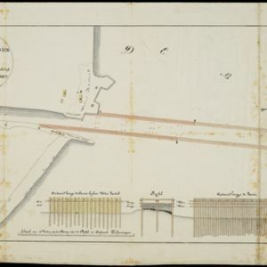
Schetze van de bank voor de Groote rivier te Batavia, met de geprojekteerde en gedeeltelijk geexecuteerde zee hoofden
1823
Indonesia
Plan of improvements to the pier at the port in Batavia (Jakarta): new parts added in 1822 are labelled AB; numbers record the change in water depth (red is before the improvements; black is after). Planned future works (labelled BC) are also shown.
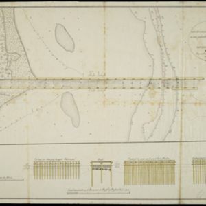
Schetze van de nieuwgemaakte zeehoofden en een gedeelte der bank voor de Groote rivier te Batavia met derzelver uitbreiding zedert 1817 tot 1823
1823
Indonesia
Plan of improvements made to the pier at the port in Batavia (Jakarta), including profile drawings of the construction parts. Lines indicate the changing position of the beach and the sandbank over the years, and numbers show the water depth.

Schetze van de bank met derzelver uitbreiding zedert 1817 voor de Groote rivier te Batavia, benevens de geprojekteerde en gedeeltelijk geexecuteerde zee-hoofden
1823
Indonesia
Plan of improvements made to the pier at the port in Batavia (Jakarta): red lines show new parts added in 1822; numbers record the change in water depth (red is 1818; black is 1823). Planned future works and the ‘Waterkasteel’ fort are also shown.

Schets der verrigte werkzaamheden aan de zee hoofden op de bank voor de Groote rivier te Batavia
1822
Indonesia
Plan of improvements made to the pier at the port in Batavia (Jakarta): red lines show new parts added in 1822; numbers record the change in water depth (red is 1818; black is 1822). Planned future works and the ‘Waterkasteel’ fort are also shown.

Map of the River of Don-nai from Cape St. James to the city of Saigon
1820
Vietnam
A map to aid in the navigation of the rivers leading to Saigon (Ho Chi Minh City, Vietnam). Details include bathymetry (water depth), currents, and a side view (or ‘elevation’) of hills to use as a landmark. Tides are described in written remarks.


Situatie-kaart van een gedeelte der stad Batavia benevens de bank voor de Groote rivier
1817
Indonesia
Plan of the canals and rivers flowing through the city of Batavia (Jakarta), passing through the port before reaching the pier and the bay. The bay has a sand bank and figures for water depth. There are profile drawings of two of the city’s rivers.


