Search

Search Results

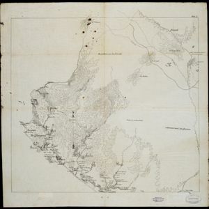
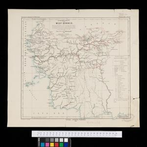
Overzichtskaart der residentie Wester-afdeeling van Borneo

event1896

location_onIndonesia

Map of western Borneo, divided into administrative districts. Mountains and larger settlements are marked with their height. A flag indicates a military garrison. A list of the districts notes their type of local ruler (Sultan, Prince etc.).

Kaart van de residentie Banka

event1896

location_onIndonesia

Map of the island and residency of Bangka, divided into districts and sub-districts, and featuring mountains, rivers, wetlands, and settlements. The surrounding seas are marked with buoys, depth lines, anchor points, shoals and reefs.

Kaart van de residentie Oostkust van Sumatra

event1896

location_onIndonesia

Detailed topographical map of the east coast of Sumatra, spread over 36 sheets. The area’s farms are listed and shown on the map within yellow borders, with types of crop grown. There is a detailed plan of Medan, and five inset maps of other towns.

Reiserouten nach dem Posso See (Central-Celebes)

event1896

location_onIndonesia

Map of routes to and around Lake Poso, central Celebes (Sulawesi) by the Dutch missionary and ethnographer Albert Christian Kruyt. The legend records types of rocks found at points along the route.

Kaart van het gebied bezet in Groot-Atjeh

event1895

location_onIndonesia

A large-scale map of Aceh, north Sumatra, spread over four sheets with details such as routes (rivers, roads, railways), crops (rice, banana, pepper, sugarcane, bamboo), land features (mountains, forests, wetlands) and settlements (cities, villages).

Sumatra: Residentie Benkoelen (Bengkoelen)

eventc.1894-1895

location_onIndonesia

Map of the residency of Benkoelen (Bengkulu, southwest coast of Sumatra), over 10 sheets, with an inset map of the city of Bengkoelen (Bengkulu). Types of crops—coconut, rice, alang-alang, nipah palm, coffee—are marked. Sheet number 8 is missing.

Java: Residentie Besoeki

event1895

location_onIndonesia

There are over 100 sheets of this very large-scale (1:20,000) topographic map of the regency of Besoeki, Java. Cities and villages, roads, railways and rivers, crops and many more features are all shown in great detail.

[Pad van Tangsé naar Kroeng Sabé]

event1895

location_onIndonesia

Map of a path from Tangsé (Tangse) at the top right, southwest to Kroeng Sabi (Krueng Sabee) on the west coast of Aceh, Sumatra. The route crosses mountains and then follows a river to the coast.

Residentie Soerabaja

event1895

location_onIndonesia

There are 64 sheets of this very large-scale (1:20,000) topographic map of the regency of Soerabaja (East Java). Cities and villages, roads, railways and rivers, crops and many more features are all shown in great detail. First sheet is an overview.

Stromkarte von West Borneo... mit Angabe der Stationen und Routen der Niederländischen Expedition in den Jahren 1893 und 1894

event1895

location_onIndonesia

The route of a late 19th century expedition by Dutch geologists, botanists, ethnographers and zoologists is marked on this map of southwest Borneo. Mountain peaks which were surveyed by the geologists are highlighted with a red circle.

Topographische kaart der residentie Soerabaja

event1895

location_onIndonesia

The residency of Soerabaja, East Java, featuring crops (coffee, coconut, sugarcane, rice, alang-alang, bamboo) and fishing ponds. Three inset maps: a triangulation map; a map of distances between settlements by types of transport; Bawean Island.

Topographische kaart der residentie Tegal

event1895

location_onIndonesia

The lower half of this two-sheet topographic map of the residency of Tegal, Central Java is dominated by mountains, with the upper half split between forests and rice paddies, and the larger settlements near the coast.

close