Search

Search Results

Residentie Soerabaja

event1895

location_onIndonesia

There are 64 sheets of this very large-scale (1:20,000) topographic map of the regency of Soerabaja (East Java). Cities and villages, roads, railways and rivers, crops and many more features are all shown in great detail. First sheet is an overview.

Java

event1894

location_onIndonesia

This detailed late 19th century map shows Java divided into regencies, and features mountains, land and sea routes, and an inset map of the port city of Batavia (Jakarta). It was designed to be folded within book covers so it could be easily carried.

Kaart van Lombok

event1894

location_onIndonesia

Map of Lombok in the Lesser Sunda Islands published by the Dutch newspaper ‘Ierseksche en Thoolsche Courant’. It mainly focuses on roads and paths between the larger settlements, with rivers and mountains also marked.

Topographische kaart van het eiland Biliton

event1894

location_onIndonesia

This map of the island of Billiton (Belitung, Indonesia) features mountains, rivers, railways, roads, settlements, coconut plantations and administrative borders. An inset map shows the island’s port and capital city Tanjung Pandan.

Topographische kaart van de residentie Preanger regentschappen

event1894

location_onIndonesia

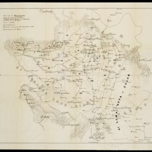
The residency of Preanger (Parahyangan), West Java, with plantations (coconut, coffee, tea, cinchona (‘kina’), betel, teakwood, bamboo) and crops (rice, sugarcane, alang-alang). Two inset maps: a triangulation map, and a map of land route distances.

Kaart van der residentie Soerabaja

event1893

location_onIndonesia

A map of the residency of Soerabaja (East Java) divided into regencies, departments and districts. There are large fishing ponds around the coasts. An inset map shows distances between settlements by road, tracks and paths.

Schets-taalkaart van de Kleine Soenda eilanden

event1893

location_onIndonesia

This map is colour-coded to show the different languages and dialects spoken in the Lesser Sunda Islands in the late 19th century.

Overzichtskaart en bladwijzer van de residentie Kediri

event1893

location_onIndonesia

This overview map of the residency of Kediri (East Java, Indonesia) features roads, railways and paths. It is divided into five regencies, which are subdivided into 28 districts, which are numbered and listed. Major settlements are also marked.

Kaart van de residentie Preanger regentschappen

event1893

location_onIndonesia

A map of the residency of Preanger (West Java) spread over three sheets and divided into regencies, departments and districts. An inset map shows distances between cities, towns and villages by road, tracks and paths.

Kaart der landbouw-ondernemingen in Oost-Java

event1892

location_onIndonesia

This map shows agricultural enterprises in eastern Java in the late 19th century. Land ownership, crops (cassava, kapok, peanuts, tobacco), factories (oil, sugar, coffee), and the offices of government officials are also shown.

Kaart van de Karo landen (Oost Sumatra)

event1891

location_onIndonesia

A map recording five Dutch expeditions through the Karo Lands of northern Sumatra. The mountainous terrain is represented by contour lines, with peaks’ heights marked. The names of groups of the indigenous Karo people are shown in large letters.

Kaart van de Residentie Kediri

event1891

location_onIndonesia

A map of the residency of Kediri (East Java) divided into regencies, which are then subdivided into districts. Mountains, roads, railways and rivers are shown. An inset map shows distances between settlements by road, tracks and paths.

close

  • Filter from 1733 to 1899

Current results range from 1733 to 1899