Search

Search Results

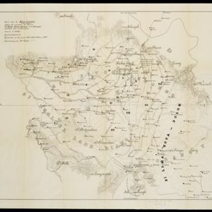
Topographische Kaart der residentie Pekalongan

event1892

location_onIndonesia

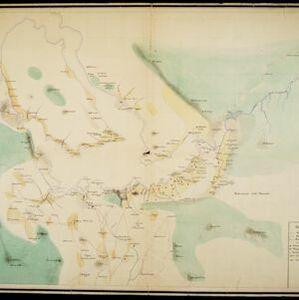
Topographic map of the residency of Pekalongan (Central Java), divided into regencies (pink borders) and districts (yellow borders). Mountains, forests, settlements, routes, crops—alang-alang, coffee, sugar, rice—factories and warehouses are shown.

Topographische Kaart van de residentie Banjoemas

event1892

location_onIndonesia

The residency of Banjoemas (Banyumas), Central Java, featuring plantations (bamboo, teakwood, coconut, coffee, cinnamon) and rice; routes (road, postal, railway), administrative borders; mountains, rivers, wetlands, forests.

Kaart van de Karo landen (Oost Sumatra)

event1891

location_onIndonesia

A map recording five Dutch expeditions through the Karo Lands of northern Sumatra. The mountainous terrain is represented by contour lines, with peaks’ heights marked. The names of groups of the indigenous Karo people are shown in large letters.

Kaart van de Residentie Kediri

event1891

location_onIndonesia

A map of the residency of Kediri (East Java) divided into regencies, which are then subdivided into districts. Mountains, roads, railways and rivers are shown. An inset map shows distances between settlements by road, tracks and paths.

Kaart van het gebied bezet in Groot-Atjeh

event1891

location_onIndonesia

A map of Groot-Atjceh and the city of Kota Radja (modern Banda Aceh) at the northern tip of Sumatra, detailing routes (rivers, roads, railways), crops (rice, banana, sugarcane, betel, reed, alang-alang, bamboo) and land features (forests, wetlands).

Schetskaart van een gedeelte van Midden Sumatra

event1891

location_onIndonesia

A map of central Sumatra spread over four sheets, divided into administrative districts, and with roads, railways and settlements marked. An inset map acts as a locator map, showing the main map’s location within Sumatra.

British Burma, Pegu division: With additions to railways up to 1891

event1891

location_onMyanmar

Topographical map of the Pegu Division of British Burma (Myanmar), spread over four sheets. In addition to mountains, forests, rivers and wetlands, rice fields, routes (road, railway, path, telegraph), villages and pagodas are marked.

Map to show lines of advance on Manipur

event1891

location_onMyanmar

Map of three routes taken by British troops through the mountains to the Indian city of Manipur (Imphal) during the Anglo-Manipur War of 1891. The map includes part of Burma to the east.

[Toba meer]

event1890

location_onIndonesia

A hand-drawn map of Lake Toba, northern Sumatra, marked with the route of an eight-day journey around the southern lake area—both on land and by boat—starting and ending in the town of Baligé.

[Omgeving van het Toba meer, afdeelingen Bataklanden, onderafdeelingen Samosir, Toba en Hoogvlakte van Toba]

event1890

location_onIndonesia

Hand-drawn map of the southern part of Lake Toba in Sumatra, with roads, rivers and paths marked. Mountains, forest and rice fields are also shown, as are missionary buildings for indigenous and European people.

Java

event1890

location_onIndonesia

This detailed late 19th century map shows Java divided into regencies, and features mountains, roads, railways, and rivers. There is also an inset map of the port city of Batavia (Jakarta).

Kaart der Bataklanden en van het eiland Nijas

event1890

location_onIndonesia

A large-scale map of northern Sumatra, spread over 16 sheets, and divided into administrative regions. The island of Nijas (Nias) is marked with the locations of local tribes, and there is a list of other maps referenced in producing the map.

close