
Search Results


Atlas van Nederlandsch Oost-Indië
c.1897-1904
Indonesia
Very detailed atlas of the entire Dutch East Indies, over 16 map sheets, with a cover and overview map. Includes topographic maps, inset maps of cities and islands, and maps featuring land and sea routes, languages, geology, colonial territory etc.
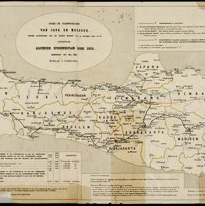
Spoor- en tramwegkaart van Java en Madoera
1894
Indonesia
The railways and tramways of Java and Madoera (Madura) are shown on this late 19th century map, including lines in use, under construction, and being planned. Each line is named, with their route, length, track gauge and construction costs listed.


Oudheidkundige kaart van Oost-Java tot aan de vorstenlanden
1891
Indonesia
This map of eastern Java uses red symbols to mark the locations of antiquarian sites, including tjandis (Hindu tombs), walls, terraces, fortifications, temples, wells, statues and cemeteries. Rivers, roads and railways are also shown.

Oudheidkundige kaart van Oost-Java tot aan de vorstenlanden
1889
Indonesia
This map of eastern Java uses red symbols to mark the locations of antiquarian sites, including tjandis (Hindu tombs), walls, terraces, fortifications, temples, wells, statues and cemeteries. Rivers, roads and railways are also shown.


- Filter from 1873 to 1898
- Dutch10
- [remove]Railway/Tramway10
- [remove]River10
- Road7
- Path3
- Telegraph/Telephone3
- Postal Route2
- Bridge1
- Canal1


