Search

Search Results

City of Mandalay and environs

event1894

location_onMyanmar

Map of the Burmese city of Mandalay on the Irrawaddy River. The city has a grid of roads and buildings, dominated by Fort Dufferin (formerly Mandalay Palace). The surrounding country has villages, crops, agricultural ponds and irrigation channels.

District Katha

event1894

location_onMyanmar

Map of the district of Katha in northern Burma (Myanmar) featuring the Irrawaddy River, and the Mu Valley State Railway (still partially under construction). High points are marked with their heights so they can be used for triangulation.

India shewing railways

event1894

location_onMyanmar

This map of India and Burma (Myanmar) shows railways, and railways sanctioned or under construction. Other maps in this series show the same area in different years of the 1890s.

Trade Routes in the Far East

event1894

location_onBrunei, Cambodia, Indonesia, Laos, Malaysia, Myanmar, Philippines, Singapore, Thailand, Vietnam

Map of stream ship trade routes around Southeast Asia. Rivers, railways, submarine telegraph cables, lighthouses (fixed, revolving and flashing), graving docks and coaling stations are marked. An inset map shows a railway route from Britain to Asia.

Upper Burma

event1893

location_onMyanmar, Thailand

Map of Upper Burma, showing the borders with Assam (India), China and Siam (Thailand), as well as internal administrative borders. Mountains with their heights, settlements, rivers and railways (completed, proposed and under construction) are shown.

District Bhamo

event1893

location_onMyanmar

Map of the district of Bhamo in northern Burma (Myanmar) featuring the Irrawaddy River, railways (proposed and under construction, including the future Burma State Railway), and mines (amber, jade).

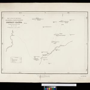
Index to relative positions of gold mining & prospecting grants: District Katha

event1893

location_onMyanmar

Map of the Katha district, Burma (Myanmar), with locations of gold mines and land allocated for prospecting. High points are marked and linked with lines to create a triangulation network. The Mu Valley State Railway and Mu River are shown.

India shewing railways

event1893

location_onMyanmar

This map of India and Burma (Myanmar) shows railways, and railways sanctioned or under construction. Other maps in this series show the same area in different years of the 1890s.

Burma and adjacent countries

event1892

location_onMyanmar, Thailand

The regional and national borders of Burma and Siam are hand-coloured on this map. Provinces, districts and states within Burma are also highlighted, and itemised in a separate list.

Burma and adjacent countries

event1892

location_onMyanmar, Thailand

The regional and national borders of Burma and Siam are hand-coloured on this map. Provinces, districts and states within Burma are also highlighted, and itemised in a separate list.

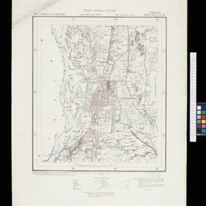
Map to accompany preliminary report on the Chin-Lushai Country

event1892

location_onMyanmar

Topographical map of the mountainous border region between India and northwest Burma (Myanmar), showing rivers, lakes, villages, towns, roads and railways. High points are marked with their heights so they can be used for triangulation.

India shewing railways with stations

event1892

location_onMyanmar

This map focuses on India, but also includes Burma (Myanmar), showing the country’s railway lines with their stations, including engine changing stations and junction stations. Part of a series of maps charting the development of the railway system.

close