
Search Results
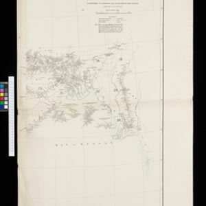

Dislocations-Karte der Indo-britischen Streitkräfte in Ost-Indien und der Russischen Streitkräfte in Asien
1892
Myanmar
Four maps showing the locations of British and Russian military units in Asia, including British and Indian (Madras Army) troops in Burma (Myanmar). Extensive legends identify individual regiments, battalions etc.

Skeleton map of the Burma and Assam frontier
1891
Myanmar
Map of Upper Burma showing the border with Assam (India) and China. The names of indigenous peoples are shown (‘Singphos’), along with the Irrawaddy River, railways and resources (‘Teak Forests’, mines (silver, copper, sulphur, rubies, coal, jade)).

South eastern frontier
c.1890-1906
Myanmar, Thailand
Very detailed large-scale map of the southeast border of Burma (Myanmar) and Siam (Thailand), divided into districts. Spread over multiple sheets, seems incomplete (some sheets appear more than once, probably from different versions of the same map).

The external trade routes of India: with tables showing the amount and value of the principal exports and imports of the chief Indian sea ports and frontier states
1886
Myanmar, Thailand
This map of the trade routes of India includes Burma (Myanmar) and part of Siam (Thailand). The Rangoon and Irrawaddy Valley State Railway is marked. There are tables showing the values of imports and exports for each area, listed by produce type.

Burma: with parts of India, China, and Siam
1886
Myanmar, Laos, Thailand
Map of Burma labelled with indigenous peoples (uppercase red text) and products (salt, copper, tea, rubies, coal, rubber, petroleum, marble, jade, silver) of each area. It also marks two journeys by the explorer J. Annan Bryce, and proposed railways.

Skeleton map of the Burma and Assam frontier
1886
Myanmar
Map of Upper Burma showing the border with Assam (India) and China. The names of indigenous peoples are shown (‘Singphos’), along with the Irrawaddy River, railways and resources (‘Teak Forests’, mines (silver, copper, sulphur, rubies, coal, jade)).

Nederlandsch Oost-Indië
1865
Brunei, Cambodia, East Timor, Indonesia, Laos, Malaysia, Myanmar, Vietnam, Thailand, Southeast Asia, Singapore, Philippines, Papua New Guinea
This detailed map of the Dutch East Indies in the mid-19th century contains a great deal of information: topographical details, settlements and administrative areas, roads, railways and maritime routes, telegraph lines, inset maps etc.

India (southern sheet)
1824
Myanmar, Malaysia, Indonesia, Singapore, Thailand
The inset map on this map of India features part of mainland Southeast Asia, with the British colonial territories—Straits Settlements, British Burma—highlighted in red, ‘protected states’ in yellow, and ‘independent states’ in green.


