Search

Search Results

Upper Burma: With additions and corrections to 1896

event1896

location_onMyanmar

Map of Upper Burma divided into Divisions and Districts, and featuring the Irrawaddy and Chindwin rivers, the Burma State Railway, and settlements including the city of Mandalay.

India shewing railways with stations

event1896

location_onMyanmar

This map focuses on India, but also includes Burma (Myanmar), showing the country’s railway lines with their stations, including engine changing stations and junction stations. Part of a series of maps charting the development of the railway system.

Stanford's Map of the Empires of China & Japan with the adjacent parts of the Russian Empire, India, Burma &c.

event1896

location_onMyanmar, Vietnam

The most northern part of Southeast Asia is shown on this map of China and Japan, with Burma (Myanmar) and Tong-King (Vietnam) appearing at the bottom of the map. Mountains, rivers and settlements are marked, as well as a railway line in Burma.

India shewing railways

event1896

location_onMyanmar

This map of India and Burma (Myanmar) shows railways, and railways sanctioned or under construction. Other maps in this series show the same area in different years of the 1890s.

Kaart van de Hoofdplaats Padang

event1896

location_onIndonesia

Map of the city of Padang, Sumatra, featuring roads, religious and military buildings, markets, warehouses and factories, and a railway station. Surrounding areas have villages and fields of rice, nutmeg, coconut, bamboo, alang-alang, sugarcane.

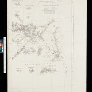
Kaart van het gebied bezet in Groot-Atjeh

event1895

location_onIndonesia

A large-scale map of Aceh, north Sumatra, spread over four sheets with details such as routes (rivers, roads, railways), crops (rice, banana, pepper, sugarcane, bamboo), land features (mountains, forests, wetlands) and settlements (cities, villages).

Java: Residentie Besoeki

event1895

location_onIndonesia

There are over 100 sheets of this very large-scale (1:20,000) topographic map of the regency of Besoeki, Java. Cities and villages, roads, railways and rivers, crops and many more features are all shown in great detail.

Kaart aantoonende districtsgewijs den aard van het grondbezit op Java en Madoera

event1895

location_onIndonesia

This map shows Java and Madura divided into regencies which are then subdivided into districts. Each district is coloured to represent land ownership (‘Communaal bezit [Communal property]’) as recorded in 1895.

Kaart van het Westelijk gedeelte bezet in Groot-Atjèh

event1895

location_onIndonesia

This map of Groot-Atjèh (Aceh, northern Sumatra) focuses on the western part occupied during the Aceh War. It shows mountains, wetlands, forests, villages, routes and crops (rice, coconut, banana, sugar, sugarcane, bamboo, alang-alang, betel).

Wegennet der gemeente Medan

event1895

location_onIndonesia

This map of the town of Medan, north Sumatra, is colour-coded to show land use, reflecting the details of a land lease contract, and including a military camp, Sultan’s palace and land, and residential, agricultural, municipal and government areas.

Residentie Soerabaja

event1895

location_onIndonesia

There are 64 sheets of this very large-scale (1:20,000) topographic map of the regency of Soerabaja (East Java). Cities and villages, roads, railways and rivers, crops and many more features are all shown in great detail. First sheet is an overview.

Upper Burma

event1895

location_onMyanmar, Thailand

Map of Upper Burma, showing the borders with Assam (India), China and Siam (Thailand), as well as internal administrative borders. Mountains with their heights, settlements, rivers and railways (completed, proposed and under construction) are shown.

close