Search Results
6 Results found
![](https://historicalmaps.yale-nus.edu.sg/rails/active_storage/representations/eyJfcmFpbHMiOnsibWVzc2FnZSI6IkJBaHBBcm9DIiwiZXhwIjpudWxsLCJwdXIiOiJibG9iX2lkIn19--587a19c6724f183bde832fbe787622dbe698687a/eyJfcmFpbHMiOnsibWVzc2FnZSI6IkJBaDdCam9MY21WemFYcGxTU0lNTkRBd2VETXdNQVk2QmtWVSIsImV4cCI6bnVsbCwicHVyIjoidmFyaWF0aW9uIn19--bc467f5637e8b6d3bfb826116f92b6bfedfbf03a/leiden-2013160.jpeg)
Kaart van de residentie Wester-afdeeling van Borneo
1898
Indonesia
Topographical map of western Borneo. Larger settlements are marked with their height above sea-level and with a flag to indicate a military garrison. They also have a letter signifying the local ruler, from Sultan to Lauthai (village elder).
![](https://historicalmaps.yale-nus.edu.sg/rails/active_storage/representations/eyJfcmFpbHMiOnsibWVzc2FnZSI6IkJBaHBBY3M9IiwiZXhwIjpudWxsLCJwdXIiOiJibG9iX2lkIn19--230833c7ee81289c92f6093244601b1a513b82e9/eyJfcmFpbHMiOnsibWVzc2FnZSI6IkJBaDdCam9MY21WemFYcGxTU0lNTkRBd2VETXdNQVk2QmtWVSIsImV4cCI6bnVsbCwicHVyIjoidmFyaWF0aW9uIn19--bc467f5637e8b6d3bfb826116f92b6bfedfbf03a/leiden-2017185.jpeg)
Atlas van Nederlandsch Oost-Indië
c.1897-1904
Indonesia
Very detailed atlas of the entire Dutch East Indies, over 16 map sheets, with a cover and overview map. Includes topographic maps, inset maps of cities and islands, and maps featuring land and sea routes, languages, geology, colonial territory etc.
![](https://historicalmaps.yale-nus.edu.sg/rails/active_storage/representations/eyJfcmFpbHMiOnsibWVzc2FnZSI6IkJBaHBBakFFIiwiZXhwIjpudWxsLCJwdXIiOiJibG9iX2lkIn19--78a35be61b3f070dc19d2289c4c53c870dd51e1f/eyJfcmFpbHMiOnsibWVzc2FnZSI6IkJBaDdCam9MY21WemFYcGxTU0lNTkRBd2VETXdNQVk2QmtWVSIsImV4cCI6bnVsbCwicHVyIjoidmFyaWF0aW9uIn19--bc467f5637e8b6d3bfb826116f92b6bfedfbf03a/leiden-2010995.jpeg)
Overzichtskaart der residentie Wester-afdeeling van Borneo
1896
Indonesia
Map of western Borneo, divided into administrative districts. Mountains and larger settlements are marked with their height. A flag indicates a military garrison. A list of the districts notes their type of local ruler (Sultan, Prince etc.).
![](https://historicalmaps.yale-nus.edu.sg/rails/active_storage/representations/eyJfcmFpbHMiOnsibWVzc2FnZSI6IkJBaHBBaEVEIiwiZXhwIjpudWxsLCJwdXIiOiJibG9iX2lkIn19--9d2ed37941f9433055895f0f6207a5f6df2dce3c/eyJfcmFpbHMiOnsibWVzc2FnZSI6IkJBaDdCam9MY21WemFYcGxTU0lNTkRBd2VETXdNQVk2QmtWVSIsImV4cCI6bnVsbCwicHVyIjoidmFyaWF0aW9uIn19--bc467f5637e8b6d3bfb826116f92b6bfedfbf03a/leiden-2011257.jpeg)
Kaart van het Zuidwestelijk gedeelte van het landschap Mampawah, residentie Wester-afdeeling van Borneo
1887
Indonesia
Map of the crops—coconut, alang-alang, rice, nipa palm, bamboo—grown along the Mempawah River (west coast of Borneo). There are also large areas of swampy forest, Malay mosques, shrines and graveyards, and Chinese villages, temples and graveyards.
![](https://historicalmaps.yale-nus.edu.sg/rails/active_storage/representations/eyJfcmFpbHMiOnsibWVzc2FnZSI6IkJBaHBBZHM9IiwiZXhwIjpudWxsLCJwdXIiOiJibG9iX2lkIn19--1e1a9f02a7066e8819b24397088c4ff37942e8e9/eyJfcmFpbHMiOnsibWVzc2FnZSI6IkJBaDdCam9MY21WemFYcGxTU0lNTkRBd2VETXdNQVk2QmtWVSIsImV4cCI6bnVsbCwicHVyIjoidmFyaWF0aW9uIn19--bc467f5637e8b6d3bfb826116f92b6bfedfbf03a/leiden-2010819.jpeg)
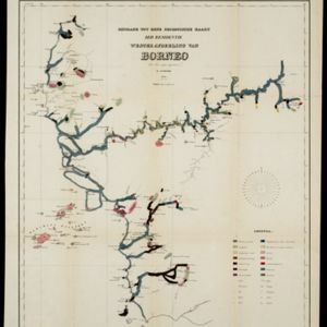
Bijdrage tot eene geologische kaart der residentie Westerafdeeling van Borneo
1858
Indonesia
A geological map of western Borneo made by a mine engineer, showing the types of soil, coal, clay, and rock (limestone, sandstone, granite, basalt), as well as gold, diamonds, tin, copper and iron found along the rivers.
- [remove]Borneo6
- Dutch East Indies6
- West Kalimantan4
- Residentie Westerafdeeling van Borneo2
- Wester-afdeeling van Borneo2
- Ambon1
- Banda Aceh1
- Banda Eilanden1
- Banda Islands1
- Bandjarmasin1
- Bangka1
- Banjarmasin1
- more Detailed Location »
- [remove]District/Administrative Border6
- Colonial Possessions2
- Civic/Metropolitan Border1
- [remove]Batavia6
- The Hague1