Search

Search Results

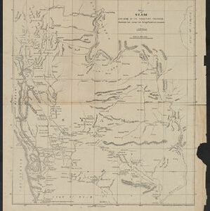
Eastern Bengal, Burmah and parts of China and Siam

event1871

location_onMyanmar, Laos, Thailand, Vietnam

The routes of nine expeditions (1830 to 1869) are marked on this map. There are also short notes about trading (e.g. at Oonoung in Burmah: ‘A bazaar, with a great variety of European goods’), and a list of other maps referenced in producing the map.

Map of Siam and some of its tributary provinces

event1870

location_onCambodia, Laos, Myanmar, Thailand

A map of Siam (Thailand) and parts of Burma (Myanmar), Cambodia and Laos, focusing on the river networks, and the mountain ranges which are represented by hachures: short lines/dashes that give a sense of the shape and steepness of terrain.

The Island of Ceylon / Burmah, Siam and Anam

event1870

location_onMyanmar, Laos, Cambodia, Thailand, Vietnam, Malaysia

This map of mainland Southeast Asia has colour-coded borders: Burmah (Myanmar) in red, Siam (Thailand) in brown, and Anam (Vietnam) in green. The British territory of Penang is also bordered in red. Independent areas are bordered in grey.

[Manuscript map of Asia and Australia]

event1870

location_onSoutheast Asia, Singapore, Brunei, Cambodia, East Timor, Indonesia, Laos, Malaysia, Myanmar, Papua New Guinea, Philippines, Thailand, Vietnam

On this hand-drawn and coloured map of Asia, the colours differentiate the colonial territories of the European powers: for example, New Guinea is divided into Dutch, British and German areas, and Borneo is split between the British and Dutch.

The central part of British Burmah with the Shan provinces of Burmah and Siam

event1870

location_onMyanmar, Thailand

The routes of eight expeditions through Burma (Myanmar) and Siam (Thailand) are shown, with text noting ‘Ancient ruins with sarcophagi, mummies’, ‘bazaar… great variety of European goods’, ‘great thoroughfare for the Chinese trading with the Shans’.

Stanford's portable map of India shewing its present divisions and the adjacent parts of Beluchistan, Afghanistan, Turkestan, the Chinese Empire, Burmah and Siam

event1869

location_onMyanmar, Indonesia, Thailand

This two-sheet map of India includes Burma (Myanmar) and Siam. British Burma—which came under British colonial rule after the first (1824–1826) and second (1852–1853) Anglo-Burmese wars—is highlighted in red.

Stanford's library map of Asia

event1862

location_onBrunei, Cambodia, East Timor, Indonesia, Laos, Myanmar, Malaysia, Philippines, Singapore, Southeast Asia, Thailand, Vietnam

Map of Asia on four sheets, with Southeast Asia on sheet four. British colonial territory—British Burma, the Straits Settlements, Sarawak—is highlighted in red, with the Dutch East Indies, Spanish Philippines and Portuguese East Timor also shown.

A sketch of the rivers of Siam from the observations of the American missionaries

eventc.1860-1869

location_onThailand

A sketch of the river networks discharging into the Gulf of Siam (Gulf of Thailand), derived from the observations of mid-19th century American missionaries. Settlements along the rivers are noted, as are areas where sugarcane was grown.

Extension of the Electric Telegraph to Canton, Hong Kong, etc. from the Port of Rangoon

event1860

location_onMyanmar, Cambodia, Indonesia, Laos, Malaysia, Singapore, Thailand, Vietnam

Map of a proposed extension of a telegraph system from Rangoon (Yangon, Myanmar) to China. Includes current and projected railways, steam ship routes, and population figures for western China. From the British magazine ‘The Illustrated London News’.

Asiatic archipelago

event1858

location_onVietnam, Myanmar, Papua New Guinea, Philippines, Singapore, Southeast Asia, Thailand, Malaysia, Laos, Indonesia, East Timor, Cambodia, Brunei

This late 19th century map of Southeast Asia shows the best maritime routes around the region, according to the time of year. There are also inset maps highlighting the rivers and southern islands of Singapore, and the sea depth around Labuan Island.

New map of Burma and the regions adjacent

event1857

location_onMyanmar, Thailand

Map of Burma spread over two sheets, labelled with the names of indigenous ‘tribes’ (uppercase red text), mountains, rivers, forests and plantations (teak, bamboo, sappanwood).

East Indies

event1855

location_onBrunei, Cambodia, East Timor, Indonesia, Laos, Malaysia, Myanmar, Philippines, Singapore, Southeast Asia, Thailand, Vietnam

Coloured borders are used to highlight the colonial territories of the British (red), Dutch (orange), Spanish (red) and Portuguese (blue) on this mid-19th century map of Southeast Asia. An inset map shows the island and strait of Singapore.

close