
Search Results
Filter
Land Routes
River
Remove constraint Land Routes: River
Language
French
Remove constraint Language: French
Simple Location
Brunei
Remove constraint Simple Location: Brunei
Simple Location
Indonesia
Remove constraint Simple Location: Indonesia
Simple Location
Myanmar
Remove constraint Simple Location: Myanmar
Simple Location
Thailand
Remove constraint Simple Location: Thailand
Simple Location
Vietnam
Remove constraint Simple Location: Vietnam
Sea Routes
Maritime Route
Remove constraint Sea Routes: Maritime Route
Political Regions
Regional Border
Remove constraint Political Regions: Regional Border
3 Results found

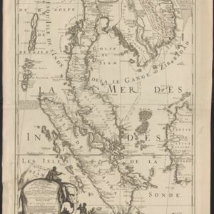
Royaume de Siam, avec les Royaumes qui luy sont Tributaires, et les Isles de Sumatra, Andemaon etc.
1742
Brunei, Cambodia, Indonesia, Laos, Malaysia, Myanmar, Singapore, Thailand, Vietnam
Map marking the routes through maritime Southeast Asia of two delegations: a French delegation from Brest, France to Siam in 1685; and a Siamese delegation from Siam to Brest in 1686. A note next to Aceh records a sea battle against Portugal in 1616.

L'Asie dressée sur les observations de Mrs. de l'Academie Royale de Sciences
1730
Brunei, Cambodia, East Timor, Indonesia, Laos, Malaysia, Myanmar, Philippines, Singapore, Southeast Asia, Thailand, Vietnam
This map features maritime routes: between Siam and Batavia; and five routes of the explorers Juan Gaetan and Olivier du Nord (dated 1542) east of the Philippines. The cartouche has a colourful illustration of Asian people in traditional costume.
- [remove]Brunei3
- Cambodia3
- [remove]Indonesia3
- Laos3
- Malaysia3
- [remove]Myanmar3
- Singapore3
- [remove]Thailand3
- [remove]Vietnam3
- East Timor2
- Philippines2
- Southeast Asia2
- [remove]River3
- [remove]Maritime Route3
- Bathymetry2
- [remove]Regional Border3


