
Search Results
8 Results found


Carte des Isles de la Sonde et du Détroit de Malaca
1791
Brunei, Indonesia, Malaysia, Singapore
Map based on the expeditions of Jean-François de Surville, a merchant captain with the French East India Company. Some details are from the diary of the French Navy officer Théobald René, Comte de Kergariou-Locmaria, who explored the region in 1785.
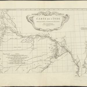
Carte de l'Inde: dressée pour la Compagnie des Indes
1752
Myanmar, Indonesia, Malaysia, Thailand
Spread over two sheets, this map of India also features the west coast of mainland Southeast Asia. There is also an inset map of the bay of Ashem (Banda Aceh, Sumatra), featuring bathymetry (sea depth), islands, shoals and reefs, and anchor points.

Royaume de Siam, avec les Royaumes qui luy sont Tributaires, et les Isles de Sumatra, Andemaon etc.
1742
Brunei, Cambodia, Indonesia, Laos, Malaysia, Myanmar, Singapore, Thailand, Vietnam
Map marking the routes through maritime Southeast Asia of two delegations: a French delegation from Brest, France to Siam in 1685; and a Siamese delegation from Siam to Brest in 1686. A note next to Aceh records a sea battle against Portugal in 1616.

L'Asie dressée sur les observations de Mrs. de l'Academie Royale de Sciences
1730
Brunei, Cambodia, East Timor, Indonesia, Laos, Malaysia, Myanmar, Philippines, Singapore, Southeast Asia, Thailand, Vietnam
This map features maritime routes: between Siam and Batavia; and five routes of the explorers Juan Gaetan and Olivier du Nord (dated 1542) east of the Philippines. The cartouche has a colourful illustration of Asian people in traditional costume.
- [remove]River8
- [remove]Maritime Route8
- Bathymetry7
- [remove]Regional Border8
- District/Administrative Border3


