
Search Results


Nederlandsch Oost-Indië
1865
Brunei, Cambodia, East Timor, Indonesia, Laos, Malaysia, Myanmar, Vietnam, Thailand, Southeast Asia, Singapore, Philippines, Papua New Guinea
This detailed map of the Dutch East Indies in the mid-19th century contains a great deal of information: topographical details, settlements and administrative areas, roads, railways and maritime routes, telegraph lines, inset maps etc.

Nederlandsche overzeesche bezittingen / Oost-Indië
1856
Brunei, East Timor, Indonesia, Malaysia, Singapore
Map of the East Indies, showing Dutch colonial territory (Dutch East Indies) in the mid-19th century. Coloured borders are used to highlight internal administrative regions. Three inset maps show other Dutch territories outside Southeast Asia.

Asia
c.1845
Brunei, Cambodia, East Timor, Indonesia, Laos, Malaysia, Myanmar, Philippines, Singapore, Southeast Asia, Thailand, Vietnam
Map of Asia divided into regions with coloured borders. Mainland Southeast Asia is in green, and features the ancient kingdoms of Birma (Myanmar), Siam (Thailand) and An-nam (Vietnam).
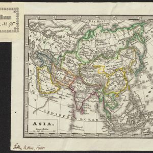
- Filter from 1739 to 1872
- [remove]Malakka24
- [remove]Malay Peninsula24
- Sumatra22
- Borneo21
- South China Sea21
- Java17
- Celebes15
- Sulawesi15
- Siam13
- Dutch East Indies12
- Maluku Islands12
- Celebes Sea11
- more Detailed Location »


