
Search Results


Route chart to India and the East
1895
Brunei, Cambodia, East Timor, Indonesia, Laos, Malaysia, Myanmar, Philippines, Singapore, Southeast Asia, Thailand, Vietnam
Map of Asia featuring steamship routes—including around Southeast Asia—connecting ports such as Penang, Singapore, Batavia (Jakarta), Saigon, Bangkok, Rangun (Yangon), Manila, Macassar (Makassar) etc. There is also an inset map of Singapore.


Asiatic archipelago
1876
Vietnam, Myanmar, Papua New Guinea, Philippines, Singapore, Southeast Asia, Thailand, Malaysia, Laos, Indonesia, East Timor, Cambodia, Brunei
This late 19th century map of Southeast Asia shows the best maritime routes around the region, according to the time of year. There are also inset maps highlighting the rivers and southern islands of Singapore, and the sea depth around Labuan Island.

Asiatic archipelago
1858
Vietnam, Myanmar, Papua New Guinea, Philippines, Singapore, Southeast Asia, Thailand, Malaysia, Laos, Indonesia, East Timor, Cambodia, Brunei
This late 19th century map of Southeast Asia shows the best maritime routes around the region, according to the time of year. There are also inset maps highlighting the rivers and southern islands of Singapore, and the sea depth around Labuan Island.
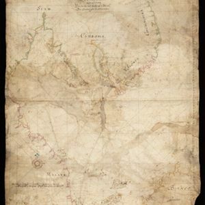
[Portolan chart of the South China Sea]
1679
Malaysia, Brunei, Cambodia, Thailand, Vietnam
A brightly-coloured hand-drawn map of the South China Sea. The compass is at the centre of a rhumbline network, a web of lines to aid navigation. Bathymetry (sea depth), islands, anchor points, shoals and reefs are also marked.


