Search

Search Results

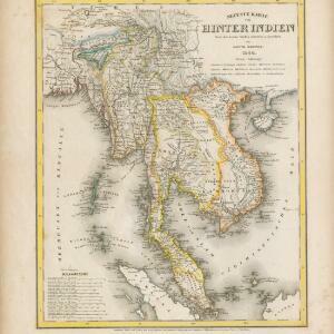
Neueste Karte von Hinter Indien

event1860

location_onCambodia, Laos, Malaysia, Myanmar, Singapore, Thailand, Vietnam

The borders on this mid-19th century map of mainland Southeast Asia are colour-coded to show kingdoms, countries and colonial territories. Twelve different scales are shown, as different countries used different measurement systems.

East India Islands

event1817

location_onBrunei, Cambodia, East Timor, Indonesia, Laos, Malaysia, Myanmar, Philippines, Singapore, Southeast Asia, Thailand, Vietnam

Although there is not much detail on this early 19th century map of Southeast Asia, in addition to place names, some rivers and ports are named, and there is even a ‘Dutch Factory’ on the west coast of Malaya.

Asia

eventc.1815-1817

location_onBrunei, Cambodia, East Timor, Indonesia, Laos, Malaysia, Myanmar, Papua New Guinea, Philippines, Singapore, Southeast Asia, Thailand, Vietnam

An early 19th century map, with the regions of Southeast Asia marked with different colours. Interestingly, Cambodia and modern Vietnam (labelled here as Cochinchina and Tonkin) are grouped with China.

Le Indie Orientali e il loro arcipelago

event1799

location_onVietnam, Myanmar, Malaysia, Philippines, Singapore, Southeast Asia, Thailand, Laos, Indonesia, East Timor, Cambodia, Brunei

A late 18th century map of Asia featuring rivers, mountains, reefs and shoals. Regions are colour-coded, with the borders of the kingdoms of mainland Southeast Asia in green, and the islands of maritime Southeast Asia in yellow and red.

Le Indie Orientali e il loro arcipelago

event1795

location_onBrunei, Cambodia, East Timor, Indonesia, Laos, Malaysia, Myanmar, Philippines, Singapore, Southeast Asia, Thailand, Vietnam

A late 18th century map of Asia featuring rivers, mountains, reefs and shoals. Regions are colour-coded, with the borders of the kingdoms of mainland Southeast Asia in green, and the islands of maritime Southeast Asia in yellow and red.

Asia and its islands according to D'Anville: divided into empires, kingdoms, states, regions, &ca.

event1794

location_onBrunei, Cambodia, Indonesia, East Timor, Laos, Malaysia, Myanmar, Papua New Guinea, Philippines, Singapore, Thailand, Vietnam, Southeast Asia

This late 18th century map features a number of labels describing the local populations, including the Kemoys ('Savage People') of the mountains of Cokin China (Vietnam), the Biayos of Borneo, and the 'Wild People' of the mountains of Pegu (Myanmar).

Les Indes orientales et leur archipel

event1785

location_onBrunei, Cambodia, East Timor, Indonesia, Laos, Malaysia, Myanmar, Philippines, Singapore, Southeast Asia, Thailand, Vietnam

A piece of paper printed with a list of the various regions of Asia, including the regions of Southeast Asia, has been adhered to the right-hand side of this late 18th century map of Asia.

La Presqu'isle de l'Inde au delà du Gange, avec l'Archipel des Indes. Partie occidentale

event1785

location_onBrunei, Cambodia, Indonesia, Laos, Malaysia, Myanmar, Singapore, Thailand, Vietnam

In the 18th century, European maps tended to use their own country’s meridian, so on this French map of Southeast Asia longitude is measured from the Paris Meridian. Eleven different scales are also shown.

Present Asia

event1783

location_onVietnam, Myanmar, Philippines, Singapore, Southeast Asia, Thailand, Malaysia, Laos, Indonesia, East Timor, Cambodia, Brunei

Coloured borders divide this late 18th century map of Asia into empires, kingdoms and regions. Five major rivers that flow south through mainland Southeast Asia are named: Aua, Pegu, Tenasserim, Menan and Camboya.

An Accurate map of India beyond the Ganges with the oriental islands, generally called East India

event1780

location_onBrunei, Cambodia, East Timor, Indonesia, Laos, Malaysia, Myanmar, Philippines, Singapore, Southeast Asia, Thailand, Vietnam

This map uses colour to identify regions in late 18th century Southeast Asia, many of which roughly correspond to modern countries: Pegu=Myanmar, Tonkin/Cochin China=Vietnam, Lao =Laos, Siam=Thailand, Malaya=Malaysia, Philippin Islands=Philippines.

Les Indes orientales et leur archipel: aßujetties aux observations astronomiqes.

event1780

location_onBrunei, Cambodia, East Timor, Indonesia, Laos, Malaysia, Myanmar, Philippines, Singapore, Southeast Asia, Thailand, Vietnam

This map of Asia has coloured borders around mainland Southeast Asia, the Philippines, the Sunda Islands (‘Isles de la Sonde’) and the Maluku Islands (‘Isles Moluques’). The cartouche features a drawing of a sailing ship and boxes of goods.

Indie Orientali di qua e di la dal Gange col loro arcipelago

eventc.1775-1785

location_onBrunei, Cambodia, East Timor, Indonesia, Laos, Malaysia, Myanmar, Philippines, Singapore, Southeast Asia, Thailand, Vietnam

From Antonio Zatta's atlas ‘Atlante Novissimo’, this late 18th century map of Asia features a decorative cartouche consisting of drawings of Asian plants, a ceramic pot emitting smoke, two archery quivers, and pearls in shells.

close

  • Filter from 1669 to 1860

Current results range from 1669 to 1860