
Search Results


Map of the Kingdom of Siam and its dependencies
1888
Cambodia, Laos, Malaysia, Myanmar, Thailand, Vietnam
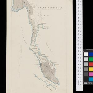
Map of the Kingdom of Siam, featuring mountains, rivers and villages, and surrounded by a yellow border (the border with Upper Burma and China in the north is undefined). The southern part of Siam is shown on an inset map of the Malay Peninsula.

India, Burmah and the adjacent parts of Beluchistan, Afghanistan, Turkestan, the Chinese Empire, and Siam
1887
Myanmar, Thailand, Malaysia, Indonesia
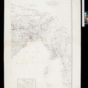
British Burma is shown on the right of this two-sheet map of India. The green areas had come under British rule after the first and second Anglo-Burmese wars, with Upper Burma (light brown) being incorporated after the Third Anglo-Burmese War (1885).

A sketch map of the East Indian possessions of the Netherlands
1886
Brunei, Indonesia, Malaysia, Papua New Guinea, Philippines, Singapore
Produced by the Intelligence Branch of the British War Office, this map shows Dutch colonial territories in maritime Southeast Asia, and their political and military divisions in Java and Madura. British and Spanish territories are also marked.

Reduzirte Karte von den Philippinen und den Sulu Inseln
1884
Philippines, Malaysia, Indonesia
Maritime map of the Philippines, with inset maps of bays showing bathymetry (sea depth), shoals, reefs and anchor points. There is also an inset map of Taal Volcano, and elevations (side views of terrestrial landmarks like mountains and islands).
India showing missionary stations
1884
Myanmar, Thailand, Malaysia, Singapore, Indonesia
This two-sheet map of India and Burma (Myanmar) shows missionary stations. The legend lists 29 European and 13 American missionary societies and churches, each with their own symbol to show their location on the map.


- Filter from 1478 to 1900
- [remove]Malaysia563
- Indonesia505
- Singapore480
- Thailand454
- Cambodia432
- Vietnam431
- Brunei427
- Myanmar423
- Laos409
- Philippines396
- East Timor355
- Southeast Asia355
- more Simple Location »
- Sumatra458
- Borneo439
- Malay Peninsula424
- Java378
- Sulawesi335
- Celebes267
- Western New Guinea233
- Siam229
- Maluku Islands222
- Malacca189
- Sunda Islands184
- South China Sea176
- more Detailed Location »


