
Search Results


Portion of coal fields tract: Upper Chindwin district
1892
Myanmar
A map surveying coal fields close to the Chindwin River in Upper Burma (Myanmar). Mountains are shown by using hachures: short lines/dashes that give a sense of the shape and steepness of terrain. Survey stations are marked with their height.

Map to accompany preliminary report on the Chin-Lushai Country
1892
Myanmar
Topographical map of the mountainous border region between India and northwest Burma (Myanmar), showing rivers, lakes, villages, towns, roads and railways. High points are marked with their heights so they can be used for triangulation.

Skeleton map of the Burma and Assam frontier
1891
Myanmar
Map of Upper Burma showing the border with Assam (India) and China. The names of indigenous peoples are shown (‘Singphos’), along with the Irrawaddy River, railways and resources (‘Teak Forests’, mines (silver, copper, sulphur, rubies, coal, jade)).


British Burma, Pegu division: With additions to railways up to 1891
1891
Myanmar
Topographical map of the Pegu Division of British Burma (Myanmar), spread over four sheets. In addition to mountains, forests, rivers and wetlands, rice fields, routes (road, railway, path, telegraph), villages and pagodas are marked.
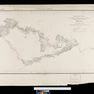
South eastern frontier: Reconnaissance survey of the route followed by Lieut. Daly's party towards the China frontier
c.1890-1891
Myanmar
A map of the route of a British Army expedition near the border of Upper Burma with China. High points are marked with their heights so they can be used for triangulation. Settlements, rivers, trade routes and footpaths are also shown.

South eastern frontier
c.1890-1906
Myanmar, Thailand
Very detailed large-scale map of the southeast border of Burma (Myanmar) and Siam (Thailand), divided into districts. Spread over multiple sheets, seems incomplete (some sheets appear more than once, probably from different versions of the same map).


The external trade routes of India: with tables showing the amount and value of the principal exports and imports of the chief Indian sea ports and frontier states
1886
Myanmar, Thailand
This map of the trade routes of India includes Burma (Myanmar) and part of Siam (Thailand). The Rangoon and Irrawaddy Valley State Railway is marked. There are tables showing the values of imports and exports for each area, listed by produce type.
- [remove]Survey of India Offices, Calcutta51
- Intelligence Branch, War Office1
- Surveyor General's Office, Calcutta1
- Dehradun19


