
Search Results


Military district no. 1: Department of northern Luzon
1900
Philippines
A map of the northwest coastal region of Luzon, Philippines made for the American military during the Philippine–American War (1899–1902). The area is divided into provinces, and major roads, settlements, mountains and rivers are marked.
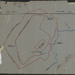
[Outline map of the capital Co-loa, North Vietnam]
1900
Vietnam
This map of the fortified settlement of Cổ Loa (near Hanoi, northern Vietnam) shows the royal city, battlements and gates, a temple and a well. Artefacts dating to the Bronze Age have been found on this early site of Vietnamese civilization.


Sketch showing positions of 1st Brigade, 2nd Division, 8th Corps, in operations against Manila
1900
Philippines
Created by the U.S. Army, this map of a small area south of Manila records Spanish and American trenches and troop and gun locations on the last day of the Spanish–American War (13 August 1898). Ground conditions (swamps, jungle, fields) are noted.

Map of the Spanish and American trenshes on the south of Manila
c.1900-1909
Philippines
Created by the U.S. Army during the Spanish-American War, this reconnaissance map of a small area south of Manila features Spanish (red) and American (blue) trenches, as well as roads, buildings and ground conditions (firm ground, swamps, fields).


Kaart van het gebied bezet in Groot-Atjèh
1898
Indonesia
A six-sheet map of Groot-Atjèh (Aceh, northern Sumatra) focusing on areas occupied during the Aceh War (1873–1904) between the Sultanate of Aceh and Dutch colonists. It shows military positions and fortifications, buildings, routes and crops.


Copy of map furnished to commanding officers, 2nd Brig., 2nd Div., 8th Army Corps, on August 12, 1898
1898
Philippines
Created by the U.S. Army during the Spanish-American War, this reconnaissance map of a small area south of Manila features Spanish (red) and American (blue) trenches, as well as roads, buildings and ground conditions (firm ground, swamps, bamboo).


