Search

Search Results

Nieuwe kaart van het eiland Java

event1816

location_onIndonesia

Map of Java marked with administrative regions, settlements, roads, mountains and rivers. There is an inset map of the port city of Batavia, with its system of rivers and canals, and its surrounding country with villages, fields and plantations.

Situatie kaart van een gedeelte der stad Batavia

event1817

location_onIndonesia

Map of the coastline of the bay of Batavia (Jakarta) showing the sand and mud bank and bathymetry (sea depth) in the bay. A plan of part of the city, including the fort, and the surrounding countryside are also included.

Situatie-kaart van een gedeelte der stad Batavia benevens de bank voor de Groote rivier

event1817

location_onIndonesia

Plan of the canals and rivers flowing through the city of Batavia (Jakarta), passing through the port before reaching the pier and the bay. The bay has a sand bank and figures for water depth. There are profile drawings of two of the city’s rivers.

Kaart van Soerabaia 1825

event1825

location_onIndonesia

This map of the city of Soerabaia (modern Surabaya, East Java) shows the Mas River flowing through the city, with wetlands near the coast, and fields, plantations and villages in the surrounding countryside. A 1931 reprint of an 1825 map.

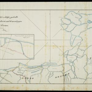
Situatie kaart van het oostelijke gedeelte van de Baai van Batavia met de mondiugen der daar in uitloopende rivieren

event1828

location_onIndonesia

A hand-drawn map of the northern part of Batavia Bay, showing rivers and the city of Batavia (Jakarta). An inset map shows a proposed canal designed to join two parts of the Antjol River.

Algemeene kaart van Nederlandsch Oostindie

eventc.1839-1855

location_onEast Timor, Indonesia, Malaysia, Singapore

This map of the Dutch East Indies is spread over eight sheets, with a hand-drawn cover sheet showing the whole area. There are numerous inset maps of islands, bays, cities etc. Two of the inset maps have a replacement map pasted over them.

Algemeene Kaart van Nederlandsch Oostindie

event1842

location_onEast Timor, Indonesia, Malaysia, Singapore

This detailed map of the Dutch East Indies in the mid-19th century is spread over eight sheets, plus a cover sheet showing the whole area. There are numerous inset maps of islands, bays, cities etc.

Kaart van het eiland Java

event1845

location_onIndonesia

This map of Java uses hachures: short lines/dashes that give a sense of the shape and steepness of terrain. The coast is marked with shoals and reefs (dotted lines and crosses), bathymetry (sea depth, in figures) and anchor points (anchor symbols).

Kaart van Java en Madura

event1850

location_onIndonesia

This map of Java and Madura uses hachures: short lines/dashes that give a sense of the shape and steepness of terrain. Roads, railways and rivers are marked, as are anchor points and coral reefs (marked with letter ‘K.’ before their name).

Kaart van Java en Madura

event1850

location_onIndonesia

This map of Java and Madura uses hachures: short lines/dashes that give a sense of the shape and steepness of terrain. Roads, railways and rivers are marked, as are anchor points and coral reefs (marked with letter ‘K.’ before their name).

Algemeene Atlas van Nederlandsche Indie

eventc.1853-1862

location_onIndonesia

Atlas featuring over 60 detailed maps of the Dutch East Indies: 24 maps cover Java; the remainder cover the rest of the Dutch East Indies. There are three index maps. (All the maps in this atlas are also presented separately on this platform.)

close

  • Filter from 1816 to 1900

Current results range from 1816 to 1900